

Training Academy
Training Academy
Training Academy
Training Academy
We’re the UK’s leading training provider in Drone Aerial Imaging Courses for
Commercial Mapping, Surveying and Photogrammetry applications.
ARC Aerial Imaging delivers and instructs several specialised ‘Phase 2’ and ‘Phase 3’ UAS training courses in aerial imaging. To find out more about each training course, click on the course link below or scroll down.


Drone Aerial Imaging for Mapping, Surveying and Photogrammetry Masterclass
Drone Aerial Imaging Masterclass for Mapping, Surveying and Photogrammetry
Drone Aerial Imaging for Mapping, Surveying and Photogrammetry Masterclass
Drone Aerial Imaging Masterclass for Mapping, Surveying and Photogrammetry
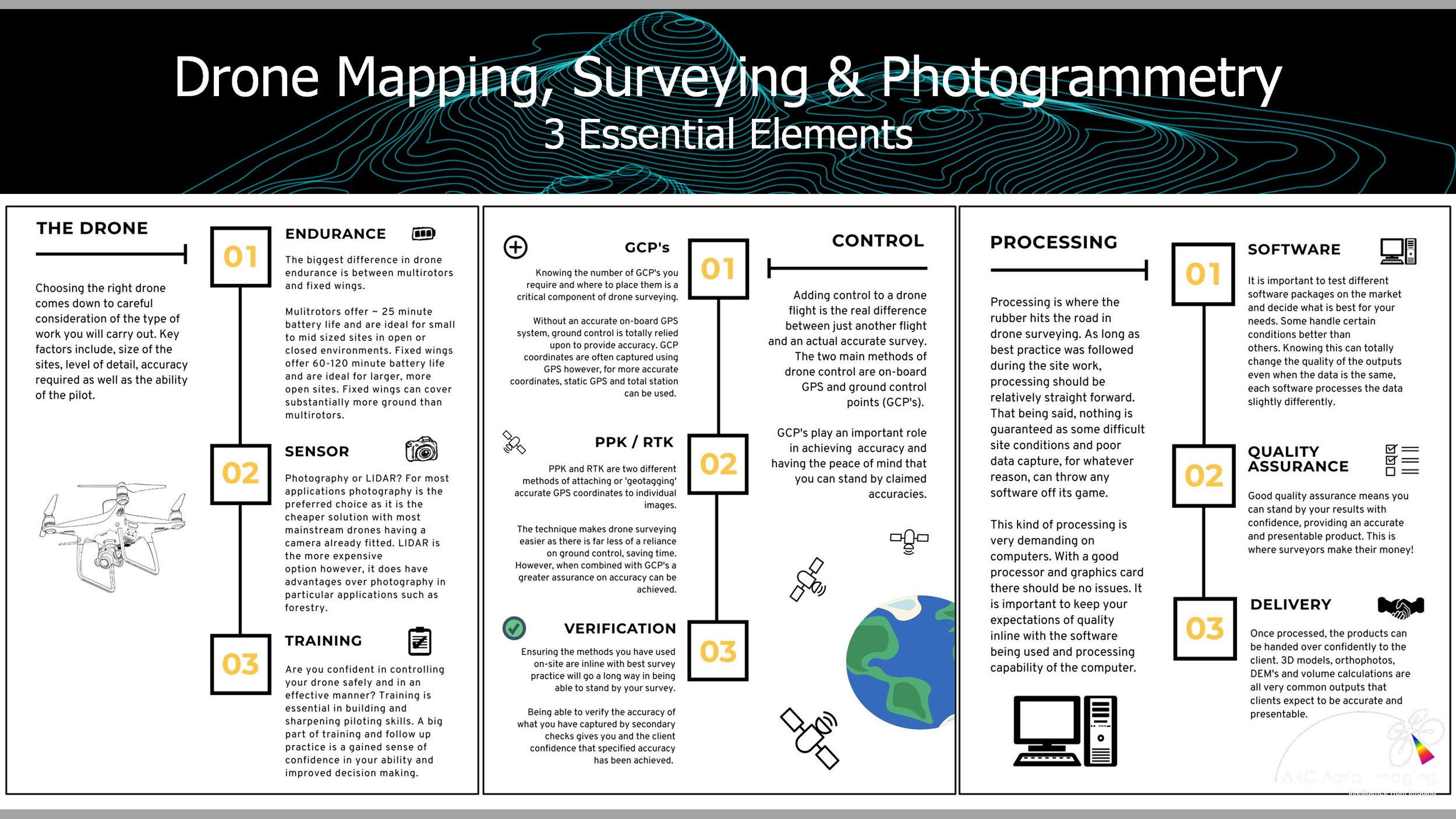
Topographic surveying with UAVs isn’t as simple as just putting the drone in the air to grab some images and uploading them into any photogrammetry processing application! Not only is it vital to have the right UAV and sensing capabilities employed in topographic mapping and surveying but by not having an informed understanding on how to utilise them will result in poorly produced and inaccurate geospatial datasets regardless of what photogrammetry software would be utilised.
This comprehensive 3-day course equips participants with the knowledge and practical skills needed to plan and capture high-quality UAV-based aerial imagery with both accuracy and consistency. It delivers a detailed understanding of imaging principles including sensor architecture, optics, radiometry, dynamic range, sensing exposure and platform motion management along with the mathematical and geometric foundations that are behind aerial image acquisition and structure from motion photogrammetric processing. Attendees also gain hands-on experience on the course through structured UAV surveying exercises and by integrating supporting geo information, such as precise point-positioning from survey-grade GNSS, that will enable them to produce survey-compliant geospatial outputs.

Frequently Asked Questions.
What are the prerequisites for the course?
Ownership of a compatible drone is desirable in order to undertake the mapping practical element of the course and attendees are required to have an A2 CofC or GVC and appropriate insurance in place.
However if attendees do not have this in place this will not preclude their course attendance as we have applicable and practical training workarounds in place.
Who is this course for?
Perhaps the largest growing sector within the drone industry and it’s one where you have the potential to specialise and charge higher rates for your expertise. This course is designed for individual commercial drone operators to corporate drone-operating entities who are seeking to up-skill and expand their current service offerings by including mapping, surveying and photogrammetry applications with drones to a high degree of confidence and to high service standards that are demanded by clients.
Will it enable me to become a surveyor and what will I be able to do after this course?
No! Upon completion of the course, attendees will not qualify as surveyors (this is not that type of course and there are more formal training pathways to become one) but will be equipped with a thorough understanding of UAV aerial imaging including the knowledge and planning skills gained in order to be able to confidently conduct enhanced aerial imaging acquisitions for undertaking commercial mapping, surveying and photogrammetry taskings and be of a highly-capable supportive service to those surveying entities
The fact that this course has also been instructed to a number of chartered surveyors who have had little/no previous knowledge of using aerial imaging, this acquired understanding has enhanced their own commercial topographic surveying-related work accompanied with the use of UAVs and is testament to the quality of this course.
Do I need prior knowledge?
No prior knowledge of mapping, surveying or photogrammetry is required - attendees can be absolute beginners to experienced surveying professionals that would be introducing drones into their workflows and this broad audience spectrum will still be able to understand the information that will be conveyed and delivered by a highly-knowledgeable and experienced tutor.
Not restricted to specific types of drone platforms, planning software or photogrammetry processing applications, this comprehensive training course can be delivered in its 3-day format at its venues or it can be brought to in-house teams at their business premises which will enable your services to fully maximise the commercial benefits that mapping, surveying and photogrammetry can bring to its drone operations. Furthermore it can also be instructed via a virtual classroom online and on an ad-hoc, one-to-one training needs basis.
2026 Training Dates
Cambridgeshire
(Black Bank Business Centre,
Little Downham)
20th - 22nd October 2026 - SPACES AVAILABLE
(23rd October if also attending the Agisoft Metashape Pro Photogrammetry Processing Course)
To attend this course on these dates and at this venue, please contact Sky Revolutions directly via their Academy webpage.
North Yorkshire
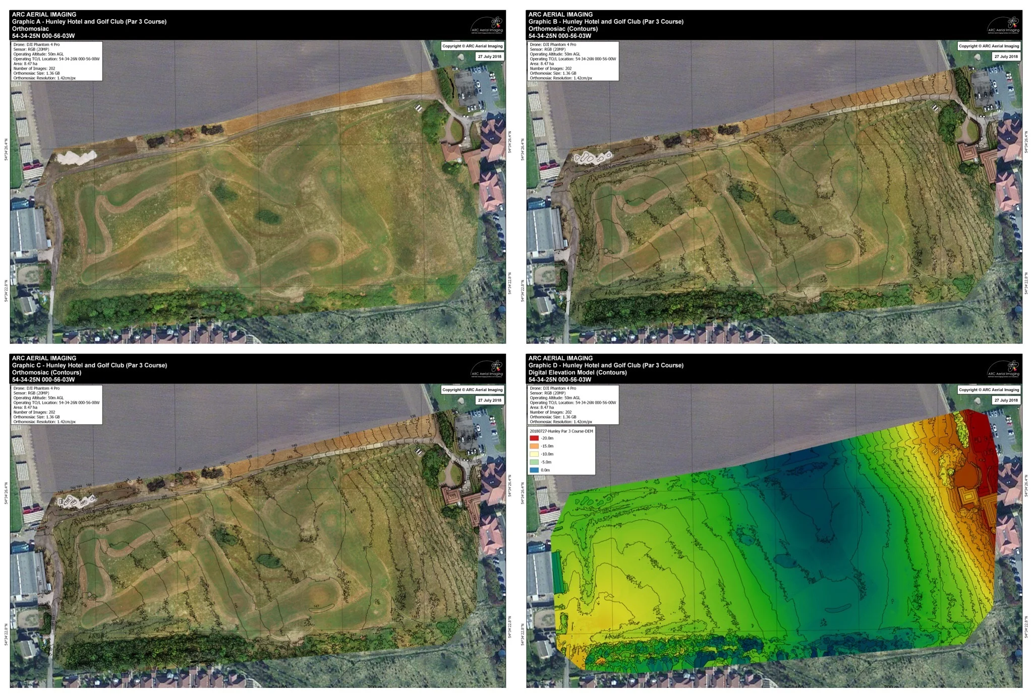
(Hunley Hotel and Golf Club,
Saltburn-By-The-Sea)
23rd - 25th September 2026 - SPACES AVAILABLE
(26th September if also attending the Agisoft Metashape Pro Photogrammetry Processing Course)
Received bookings by no later than 9th September
18th - 20th November 2026 - SPACES AVAILABLE
(21st November if also attending the Agisoft Metashape Pro Photogrammetry Processing Course)
Received bookings by no later than 4th November
The Drone Hub
(Alcar Training Camp, Merseyside)
Coming Soon…
Please contact The Drone Hub directly via their webpage.
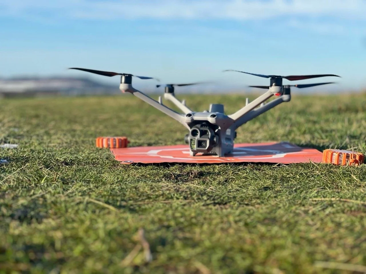
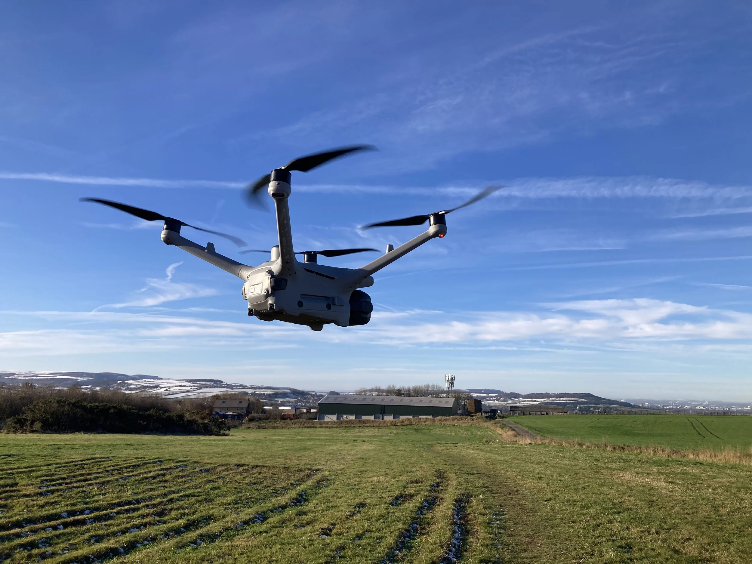
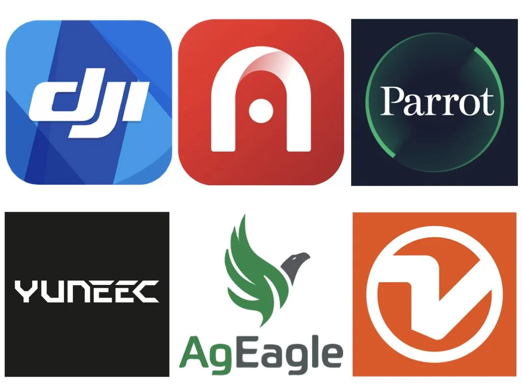
Course Applicable Drones
It’s important to utilise the appropriate UAV platforms types and sensing towards topographic-related mapping and surveying. Below are those UAVs and sensors that are compatible to use during the practical mapping/surveying element of the course:
DJI Air 2S (Android Tablet/Phone Only)
DJI Air 3*
DJI Inspire 1 (X3 or X5 cameras)
DJI Inspire 2 (X4S or X5S cameras)
DJI Matrice 100 (X3 camera)
DJI Matrice 200/210 (X4S or X5S cameras)
DJI Matrice M300/M350 (P1 camera)
DJI Matrice M400 (P1 camera)
DJI Matrice M30
DJI Matrice 4 Enterprise
Autel Evo II Series
Autel Evo Pro Series
Autel Evo Max 4T
Parrot Anafi
Parrot Anafi AI
Parrot Anafi USA
Yuneec H520E (E90X camera)
Yuneec H850/H850-RTK (E90X camera)
AgEagle eBee/eBee X/eBee Geo
Wingtra One (Gen I/Gen II/)
WingtraRay
DJI Phantom 3 Standard
DJI Phantom 3 Advanced
DJI Phantom 3 Pro
DJI Phantom 4 Standard
DJI Phantom 4 Advanced
DJI Phantom 4 Pro
DJI Phantom 4 Pro V2
DJI Phantom 4 Multispectral
DJI Phantom RTK
DJI Mavic Pro
DJI Mavic 2 Pro
DJI Mavic 2 Zoom
DJI Mavic 2 Enterprise
DJI Mavic 3/Mavic 3 Pro*
DJI Mavic 3 Enterprise
DJI Mavic 3 Multispectral
DJI Mavic 3 Thermal
DJI Mavic 4 Pro*
DJI Mini/Mini 2/Mini 3/Mini 3 Pro/Mini 4 Pro/Mini 5 Pro
DJI Lito/DJI Lito X1
DJI Mavic Air 2 (Android Tablet/Phone Only)
* Although the SDK is not available for DJI Air 3, Mavic 3 Pro (Classic and Cine) and Mavic 4 Pro drones for use with third-party mapping planning/flight apps, these drones could still be used for mapping and the course will show how with several practical flight and imaging workarounds.
Course Training Fees
North Yorkshire Venue Training
£395.00
The course's LOW TRAINING fee is inclusive of the following:
Various Drone Mapping Mission Planning Spreadsheets;
Imaging Processing and Geospatial Analysis Software;
Reference Guides;
Lunch and all day refreshments.
Including the ‘Agisoft Metashape Pro SfM Photogrammetry Processing Course’
£495.00
PLEASE NOTE - This is not a residential course and accommodation will need to be individually sought for by attendees.
Online Training
£295.00
Although instructing a specialised course is still best delivered in-person to audiences at a training venue, it could also be delivered through an online ‘virtual classroom’ without compromising the high degree of this course’s learning if three consecutive days away from the office is not possible. As a flexible training option we can accommodate this format of training to fit around those busy diaries.
Virtual attendees will still receive the same amount of comprehensive learning and course materials as the in-person venue hosted course however the practical drone mapping exercises won’t be undertaken. If you think this training would be of benefit by having it being instructed in this bespoke way, initially get in touch with your specific training requirements via our contact webpage.
Including the ‘Agisoft Metashape Pro SfM Photogrammetry Processing Course’
£395.00
North Yorkshire-held Course or Online Training Booking Form
Booking is acceptance of our Course Terms and Conditions
Bringing this course to your in-house team of UAV operatives.
If your business or organisation is utilising drones in its operations and are seeking to continually develop its services and staff professional development, ARC Aerial Imaging can also bring this as a ‘closed course’ to that organisation's premises and for an all-inclusive set instructional fee thus saving it with staff disruption and additional costs (travel, accommodation and subsistence) for this employee training.
The course is fully ‘deployable’ meaning that we can bring along our own visual presentation equipment should your organisation not have this available - all we’ll need is an appropriate room to deliver the course and an appropriate location to undertake the practical mapping exercises.
If you think this training would be of benefit by having it being instructed at your organisation and to its in-house team of UAV operations staff, get in touch with your specific training requirements and enquire about discount pricing for multiple occupancy via our contact webpage.
Could we instruct this industry-leading course on your training behalf..?
We’re always looking to collaborate/partner with other relevant training providers on an non-exclusive basis and welcome those expressions of interest. If this course interests your training organisation by having it included within its training portfolio, get in contact.
3 Day Training Schedule
3 Day Training Schedule
3 Day Training Schedule
3 Day Training Schedule
The course’s training schedule and comprehensive learning modules are based on its instructor’s own experienced surveying task management, planning methodologies, imaging acquisition techniques and workflow processes with UAVs.
Day 1
PM
AM
Fundamentals and Principles of Drone Aerial Imaging (Part 2).
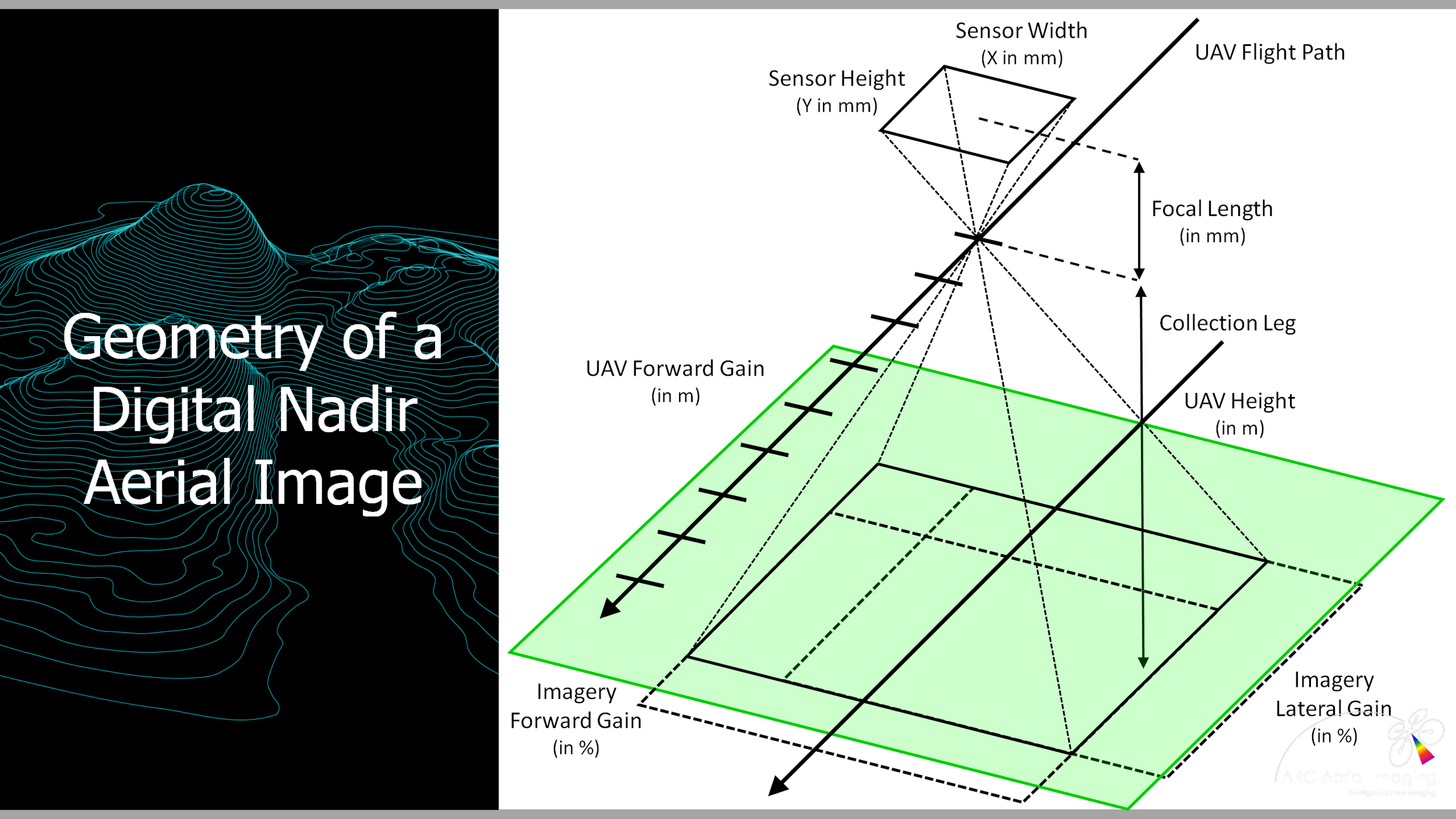
Understanding aerial imagery fields of view (FoV).
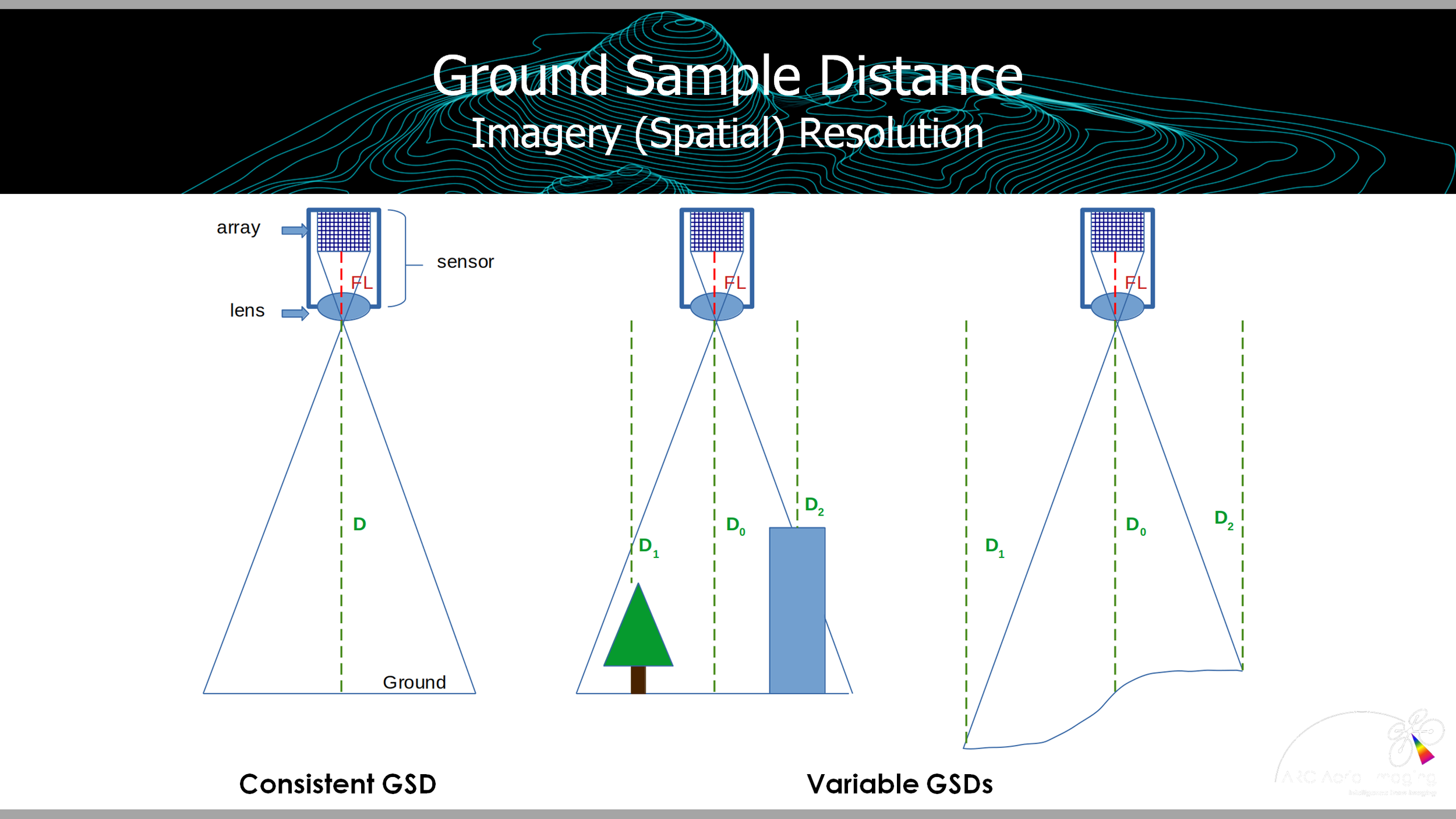
Understanding spatial resolution - Ground Sampling Distance (GSD).
How to calculate imagery FoV and GSD with mathematical
formulae.What can affect FoV and GSD on nadir aerial imagery.
Improving aerial imaging GSD and using imagery FoV to commercial advantages.
Understanding imagery resolution and their interpretabilities.
Understanding other aerial imagery format resolutions.
Fundamentals and Principles of Drone Aerial Imaging (Part 1).
Types of drones for mapping, surveying and photogrammetry uses.
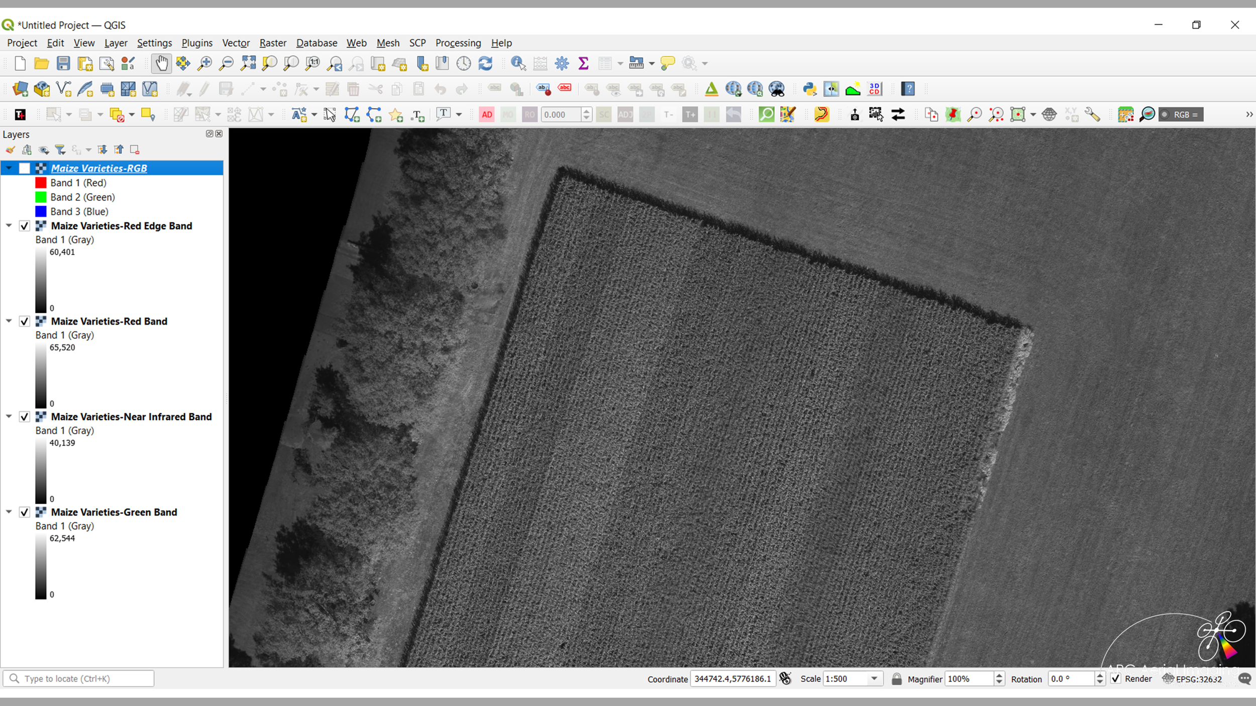
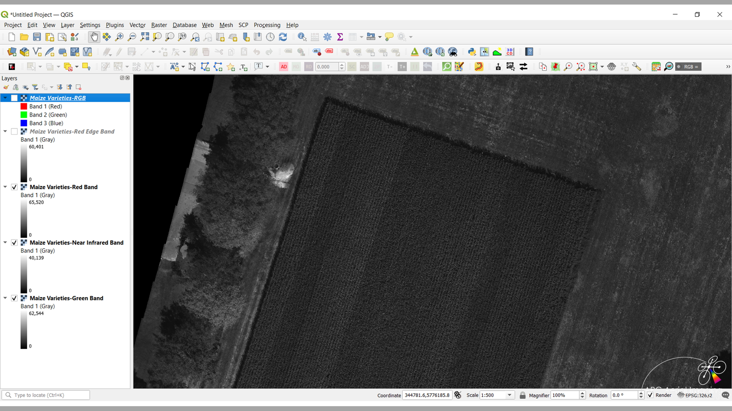
Types of UAV aerial sensors - Passive and Active (RGB, Infrared, Multispectral, LiDAR…).
Typical geospatial product outputs produced from aerial imaging.
Digital aerial imaging and sensing basics.
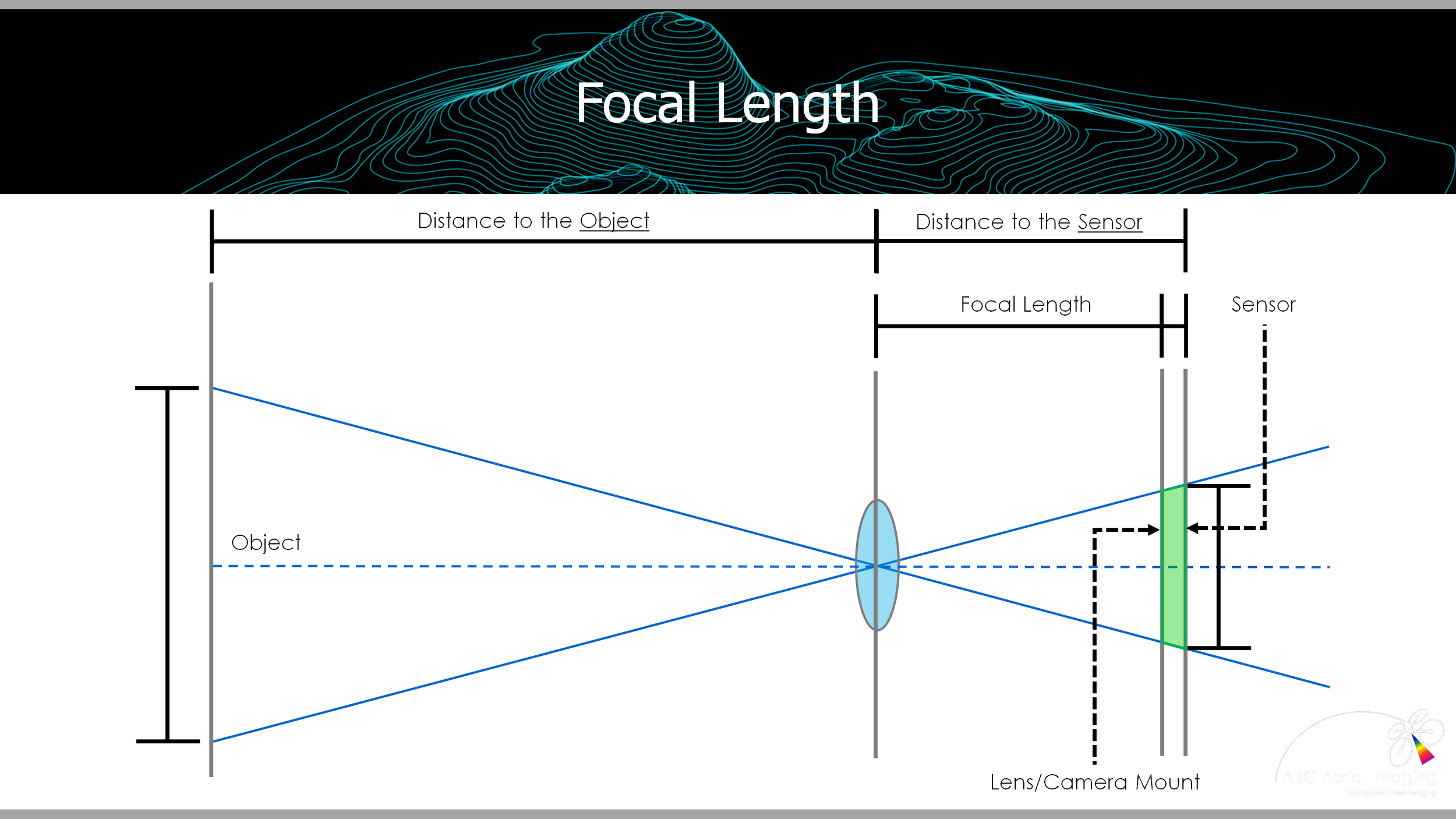
Components of an aerial sensor.
Lenses and focal lengths.
Types of sensor shutters.
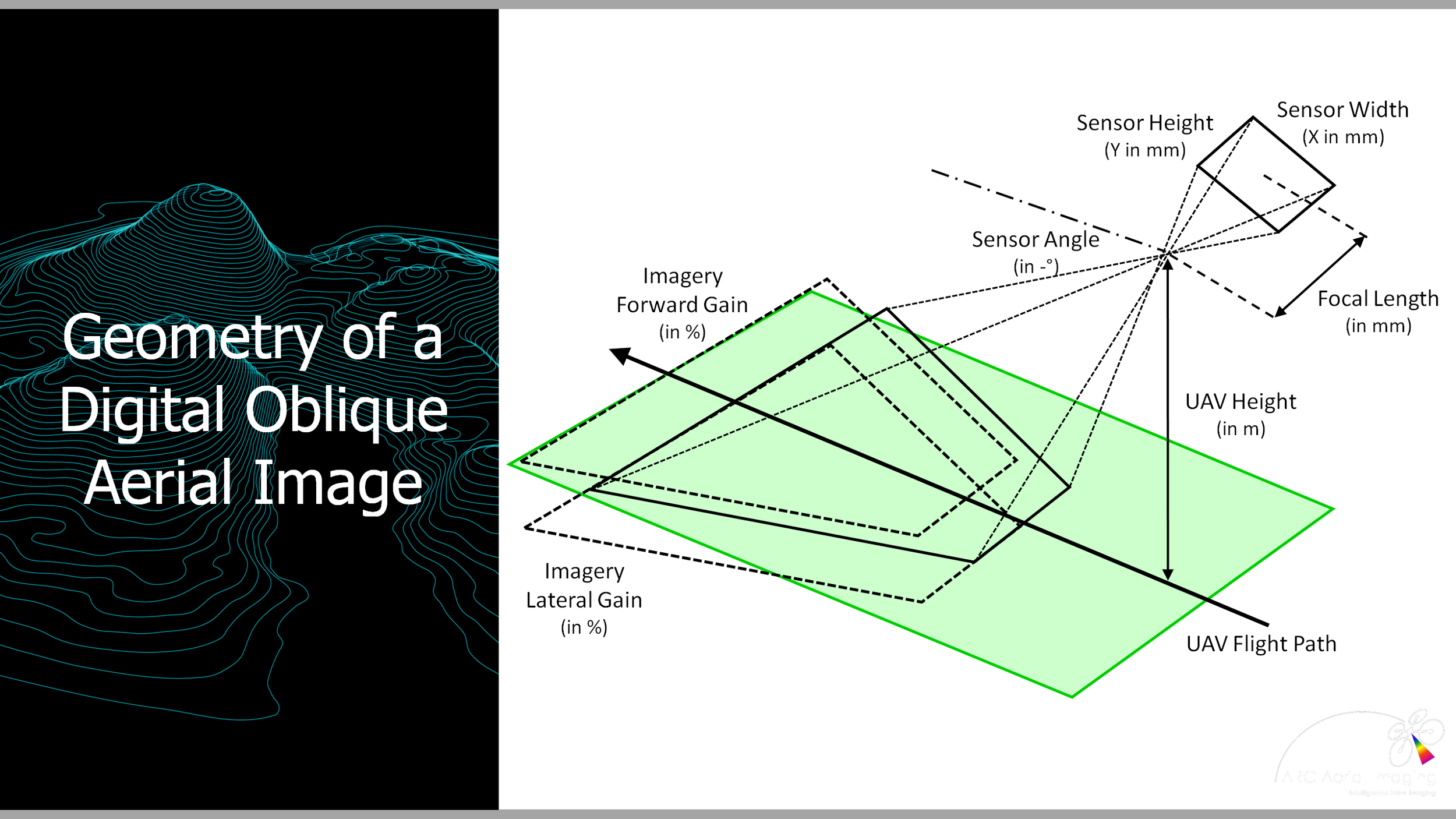
Types of aerial imaging - nadir and oblique.
Day 2
PM
AM
Drone Mapping and Surveying Practical Exercises.
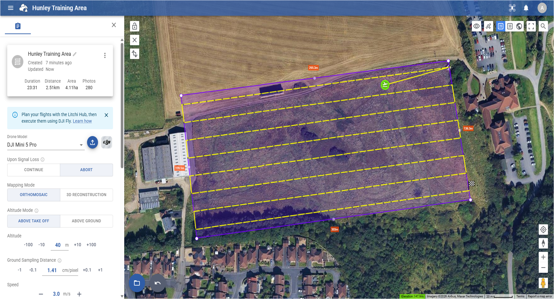
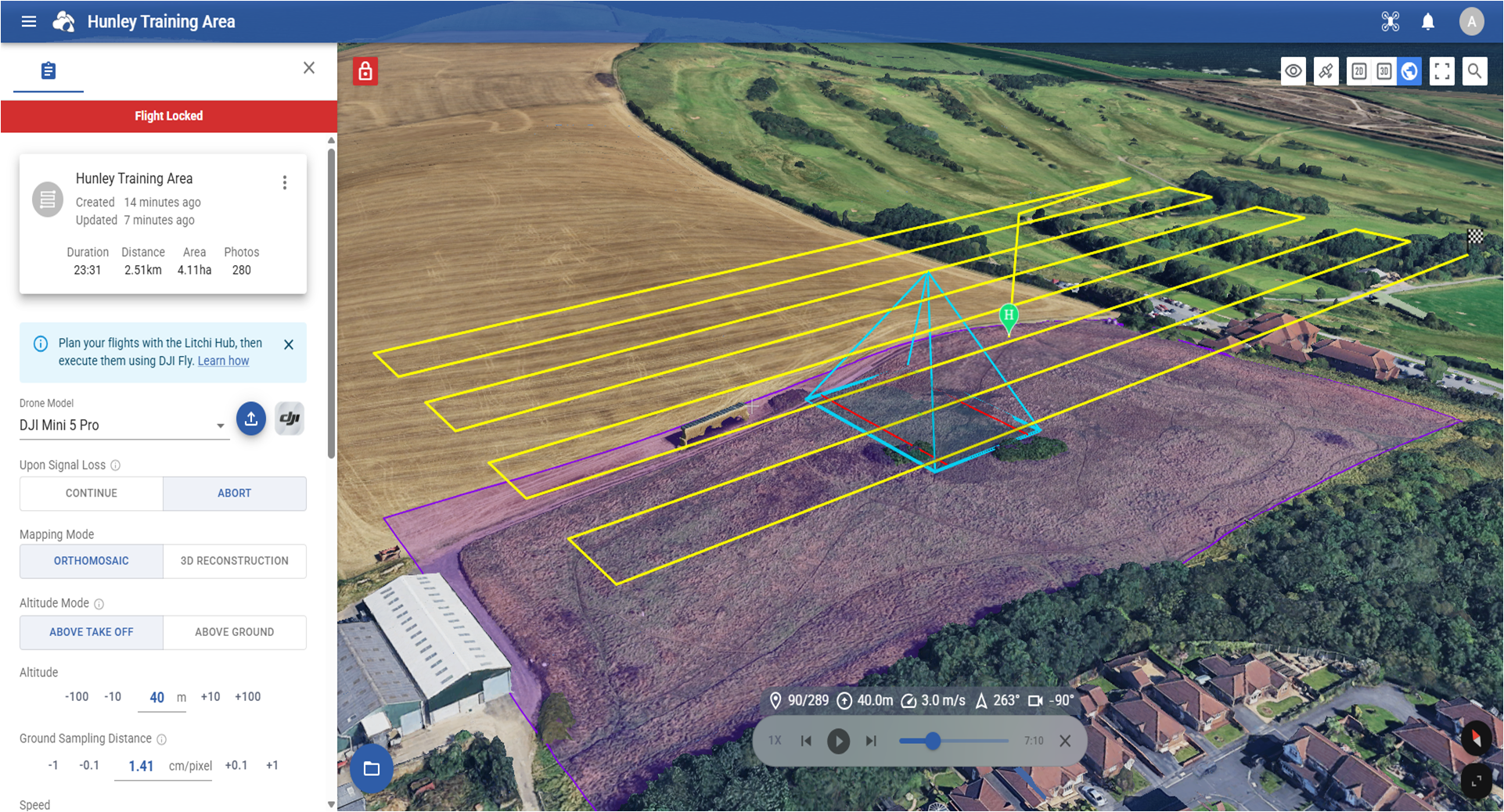
Planning aerial imaging acquisitions with semi-autonomous UAV flight software and apps.
Understanding their planning differences and uses for specific mapping and surveying-related tasks.
Creating and storing to a device a collection mission plan for ‘Drone Mapping and Surveying Practical Exercises’
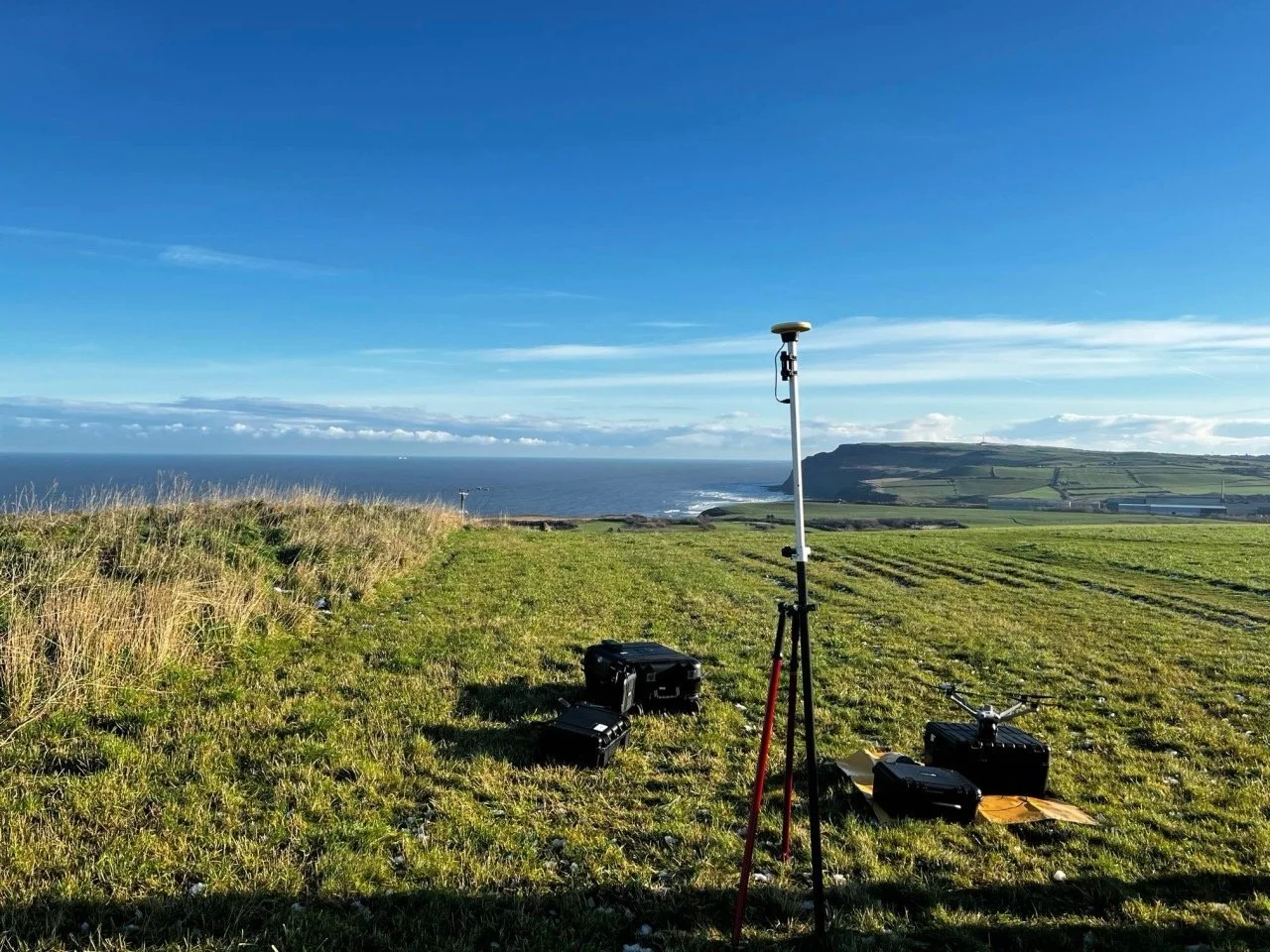
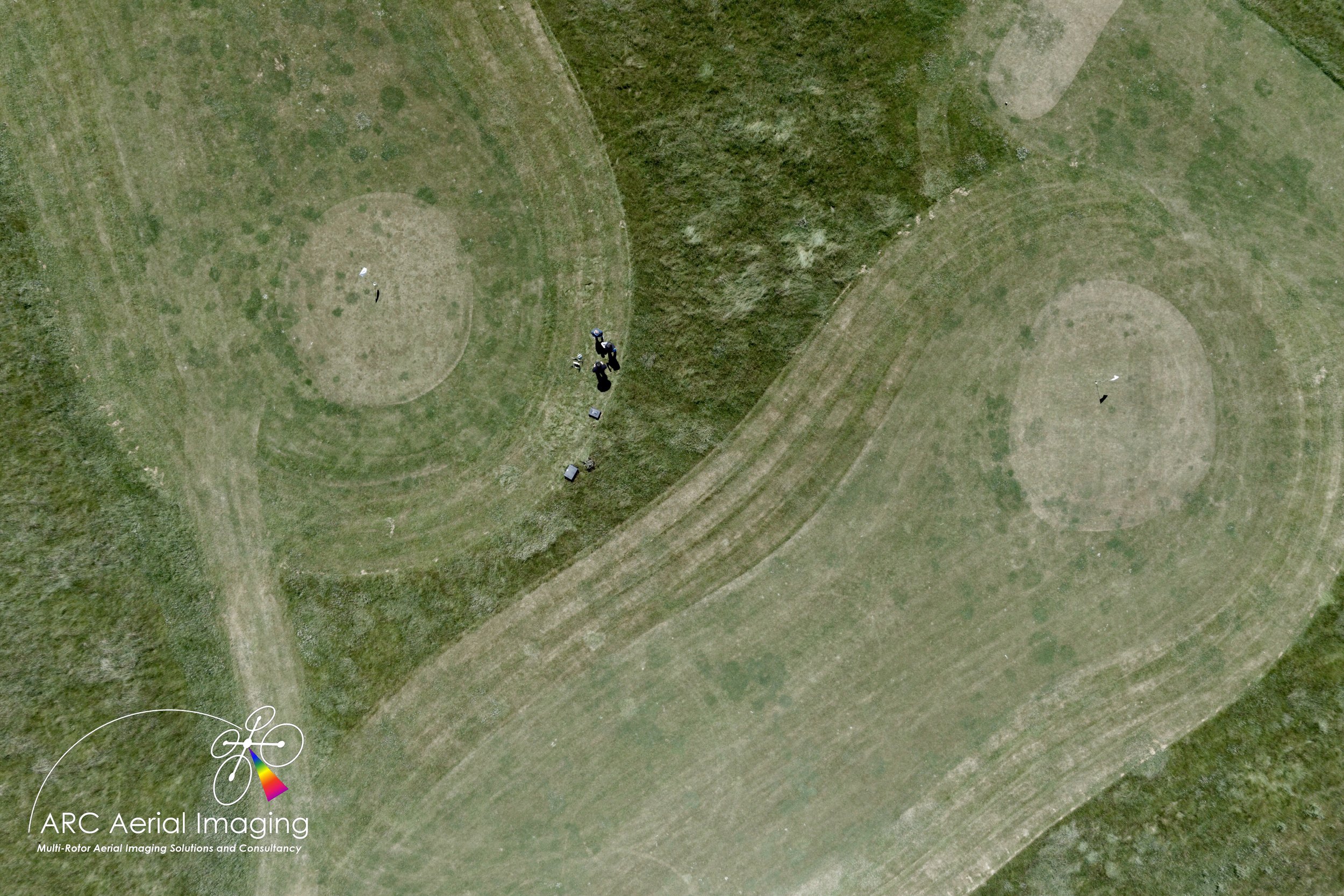
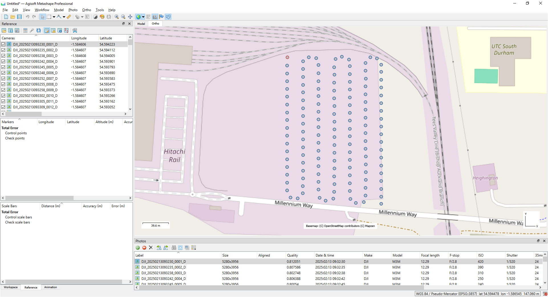
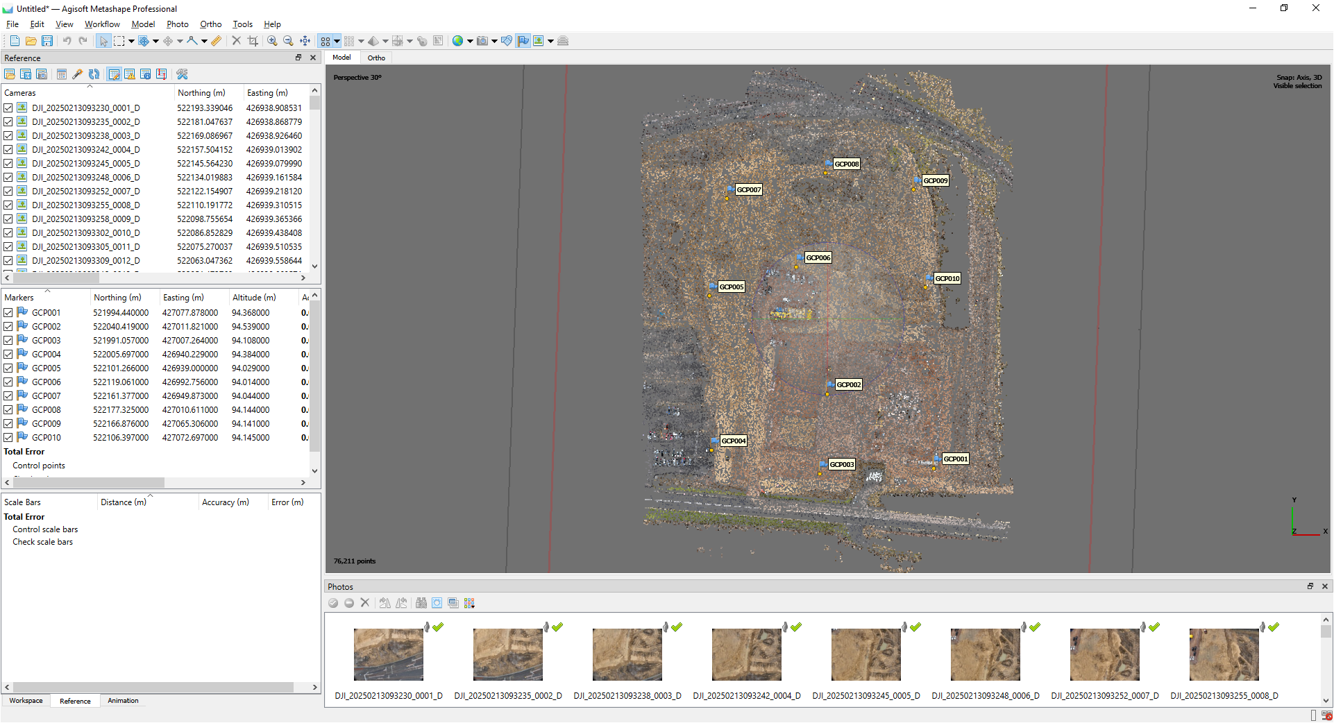
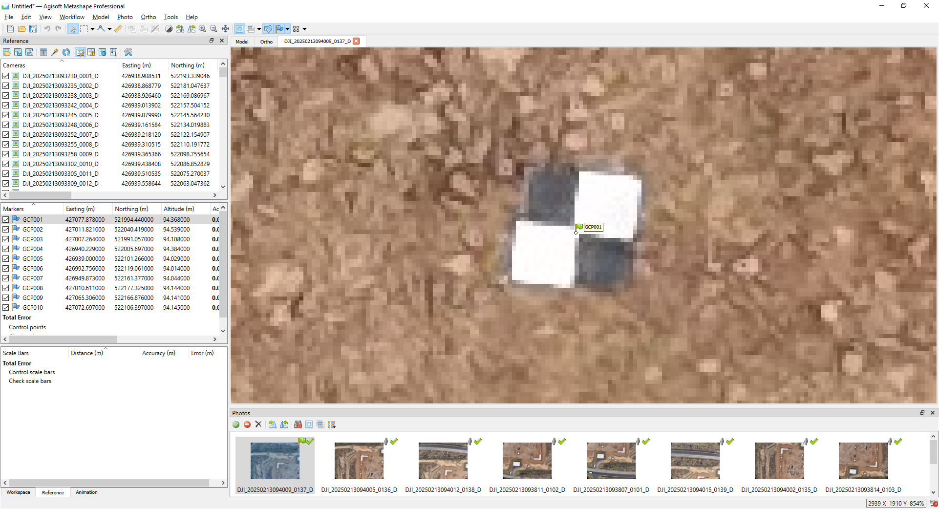
Setting out on a site and establishing accurate point positioning information/recording ‘Ground Control Points’ (GCPs) with a survey-grade RTK GNSS.
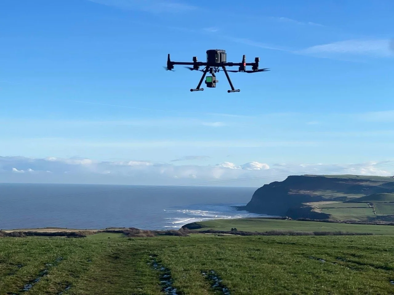
Undertake pre-planned autopiloted mapping mission plan(s) to accurately collect aerial imagery.
Drone Mapping Planning.
The ‘gist’ of Photogrammetry and what it needs from collators of digital aerial imaging
Aerial stereoscopy and parallax.
Photogrammetric principles - what it needs from digital aerial imaging.
How SfM photogrammetry works - the ‘data pipeline’.
Limitations of photogrammetry.
Managing mapping and surveying tasks.
Planning UAV aerial imaging mapping flights - the ‘imagery intelligence’ workflow cycle.
The UAV - correctly planning semi-autonomous UAV aerial imaging mapping flights.
The Sensor - applying the correct sensor settings for accurate and
high radiometric quality of aerial imaging acquisitions.Site specific planning – understanding the operating environment and weather.
Hardware - using the correct onboard imaging storage media.
DAY 3
PM
AM
Achieving Survey Compliant Geospatial Accuracy.
Understanding survey precision and accuracy.
Correction methods - RTK and PPK.
Working with geographic coordinate reference systems.
Utilising known and accurate point positioning information (GCPs) with aerial imaging to rectify, control and create ‘survey-compliant’ outputs.
Quality Assurance.
The ‘sweet planning spot’ when undertaking topographic surveys with UAVs.
Photogrammetry Processing.
Common online/cloud-based drone imagery processing options.
Comparing their processing qualities (a case study) and their geospatial datasets.
Other imagery processing options – locally-installed software.
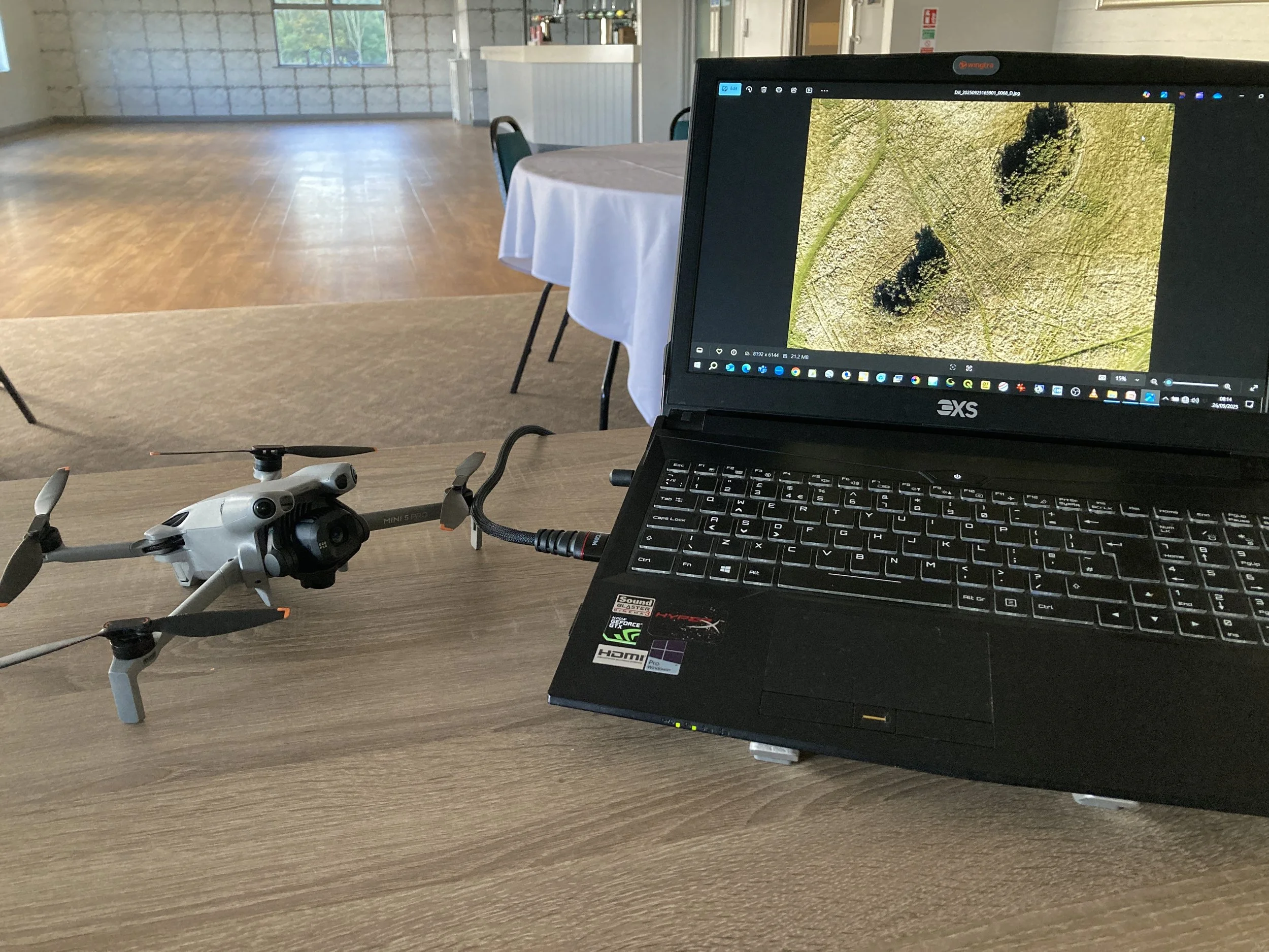
Imagery Collection Checks and Data Management.
Post UAV flight management steps - validating actual imaging collection with that of a planned-for collection.
Managing and organising aerial imagery collections.
Understanding the importance to check the collected imagery’s integrity (exposure, focus, collect overlaps…) before ingesting into any photogrammetry processing software.
Using AI (ChatGPT) for image quality checks.
Imagery metadata/EXIF checks and applying amendments using freely available desktop software.
Creating a basic ‘Imagery Collection Report’ to accompany collected aerial imagery.
Image Processing to Improve Photogrammetry.
Image radiometry and processing.
How to improve the quality of collected aerial imaging that could potentially improve the accuracy of processed geospatial datasets.
Course Testimonials
Course Testimonials
Course Testimonials
Course Testimonials
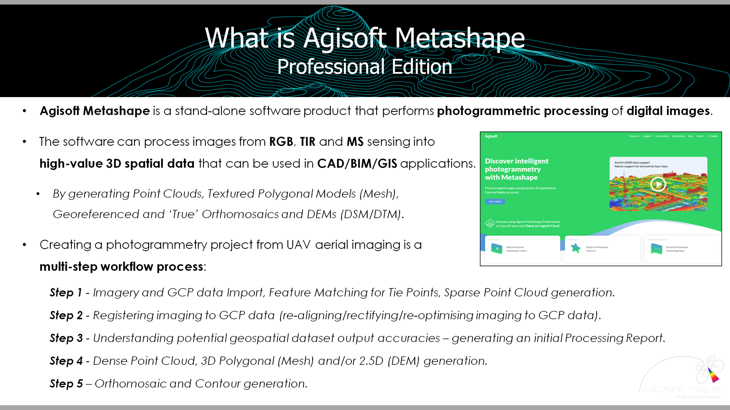
Agisoft Metashape Pro Photogrammetry Training Course for UAV Mapping and Surveying
Agisoft Metashape
(Professional Edition) Photogrammetry Training for UAV Mapping and Surveying Course
Agisoft Metashape Pro Photogrammetry Training Course for UAV Mapping and Surveying
Agisoft Metashape
(Professional Edition) Photogrammetry Training for UAV Mapping and Surveying Course
Agisoft Metashape Pro Photogrammetry Training Course
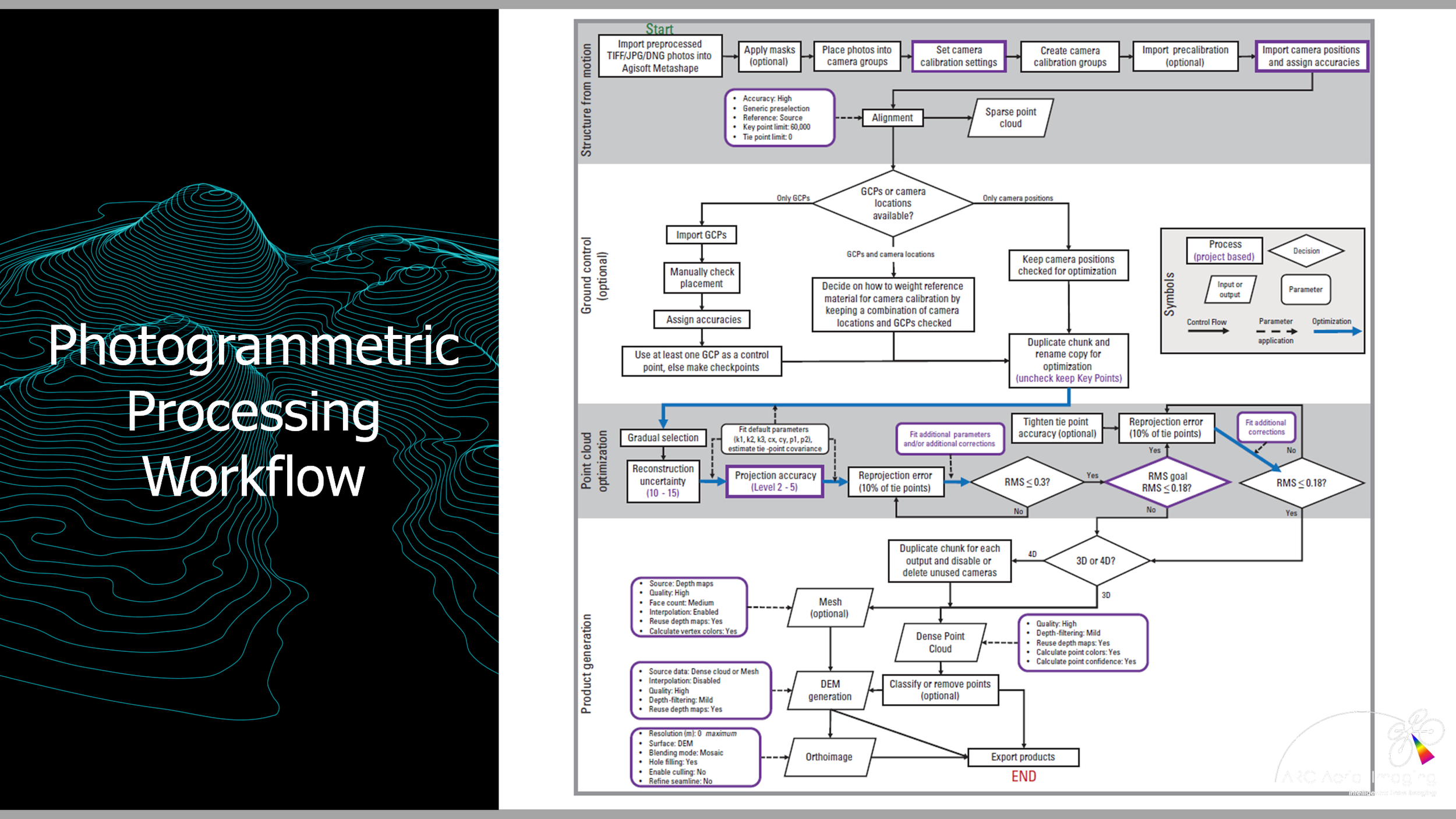
From start to finish this 1-day course, which follows on from our market-leading ‘Drone Aerial Imaging Masterclass for Mapping, Surveying and Photogrammetry Course’, covers an end-to-end photogrammetry workflow on how to generate survey-compliant geospatial datasets with Agisoft Metashape (Professional Edition) SfM photogrammetry processing software.

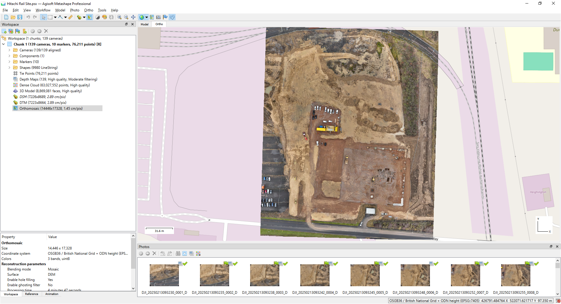
Workflow topics, accompanied with practical instructor-led step-by-step demonstrations, include:
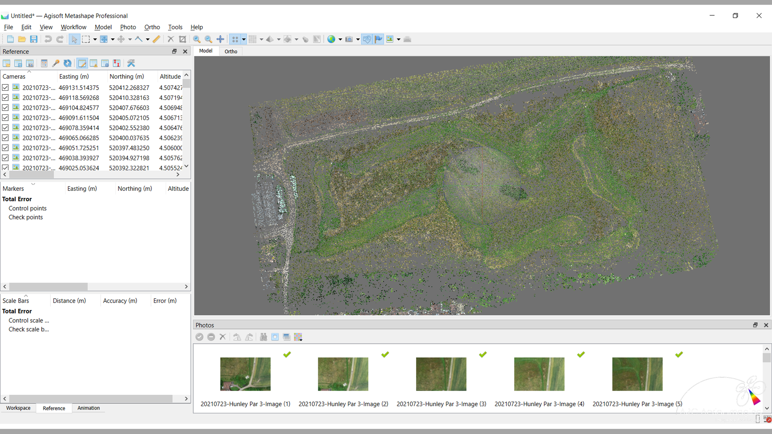
Adding and aligning UAV aerial images into a project;
Generating a Sparse (Tie) Point Cloud);
Filtering/editing and removing erroneous tie points;
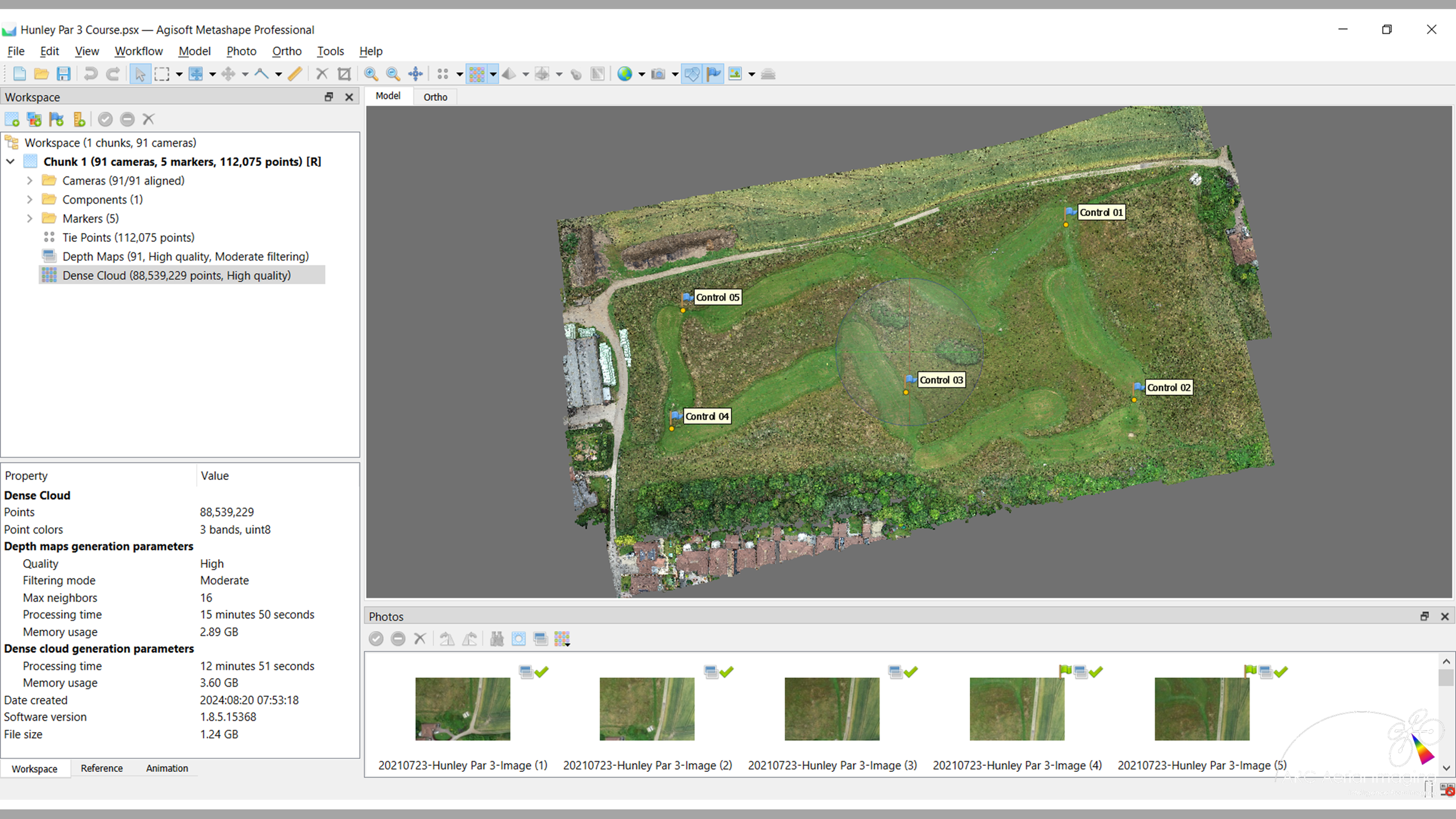
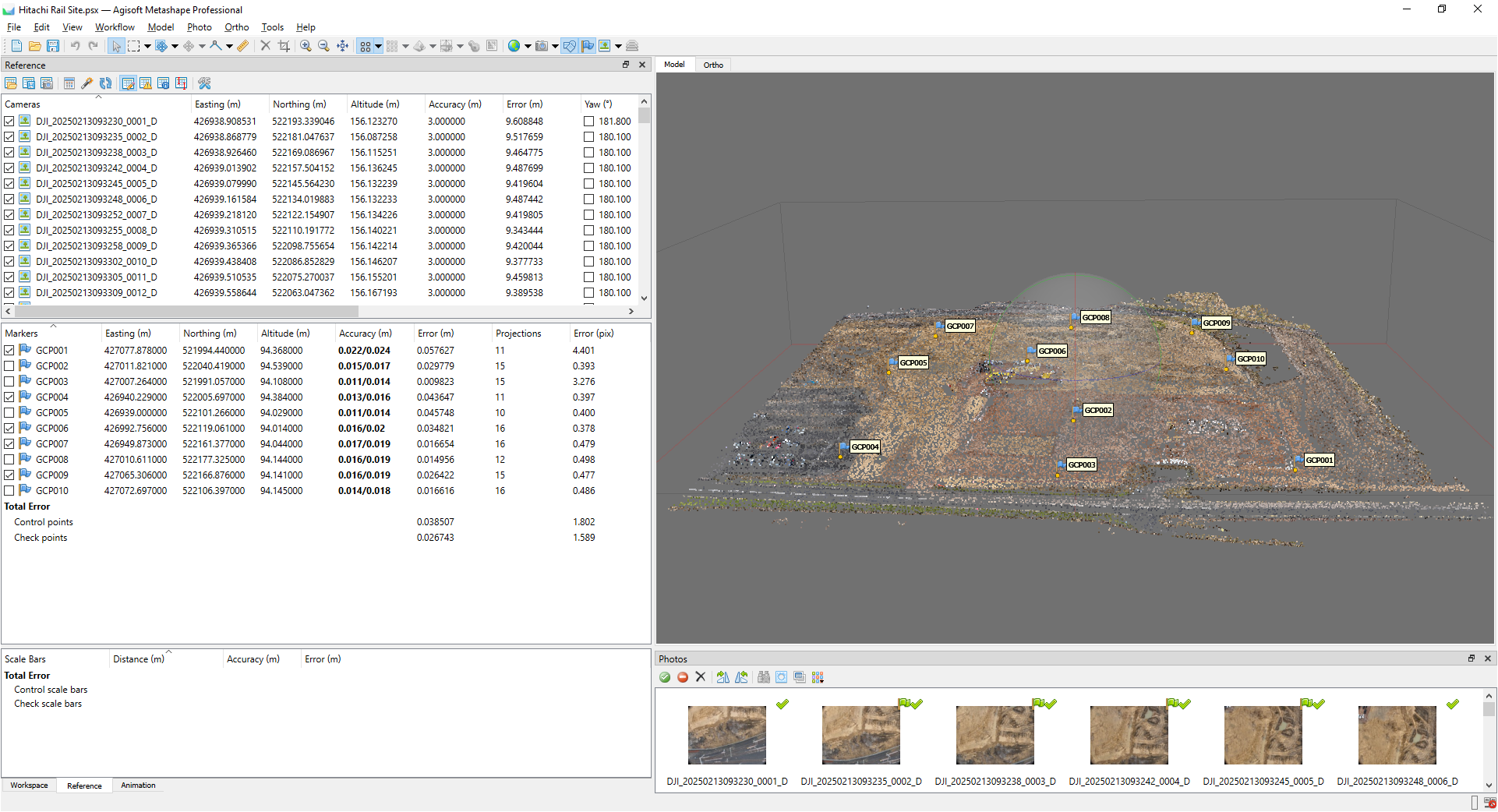
Importing Ground Control Point data and precisely registering/aligning UAV aerial images;
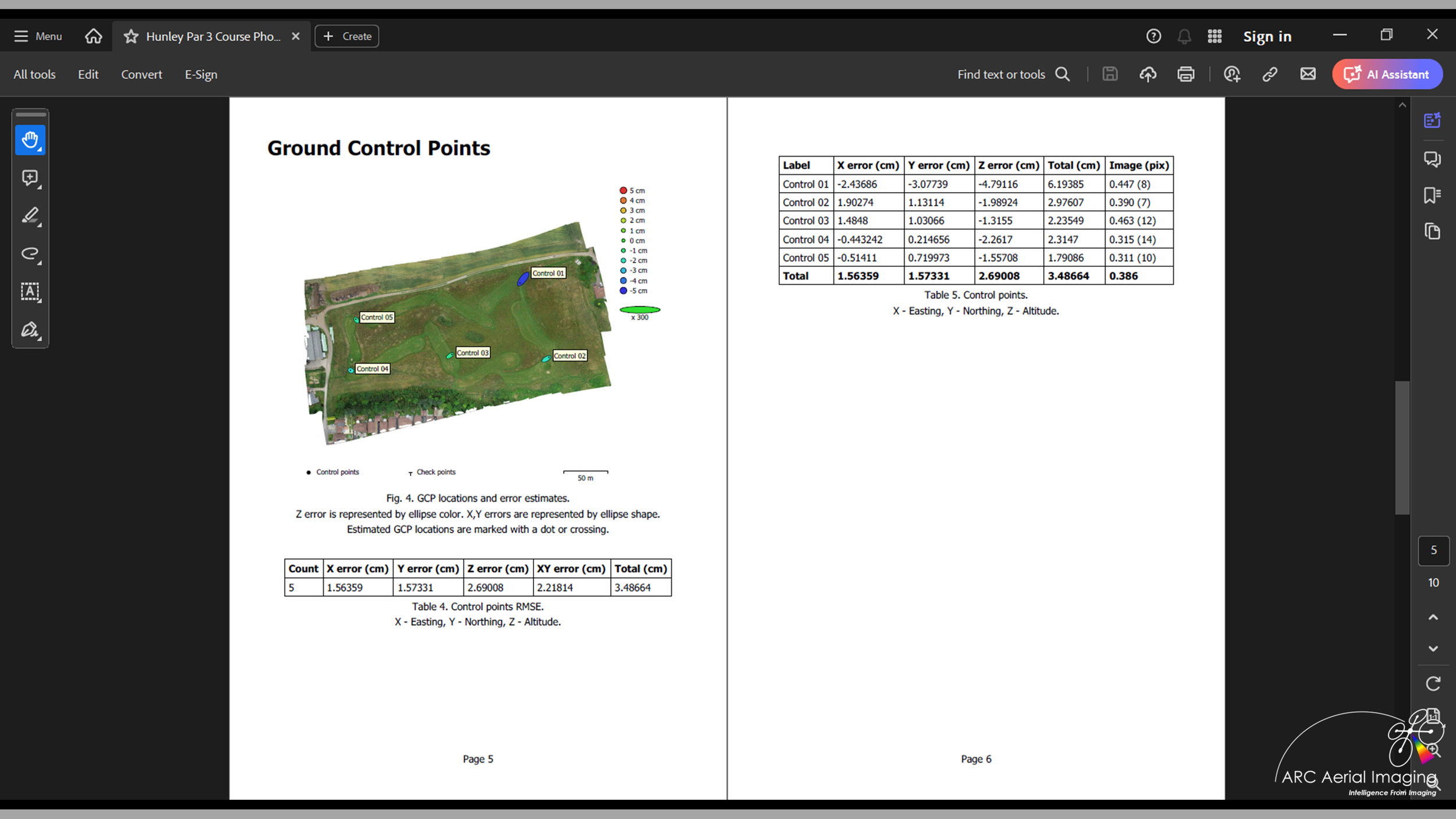
Reviewing and understanding the potential accuracies of geospatial products and in accordance to surveying standards of accuracy;
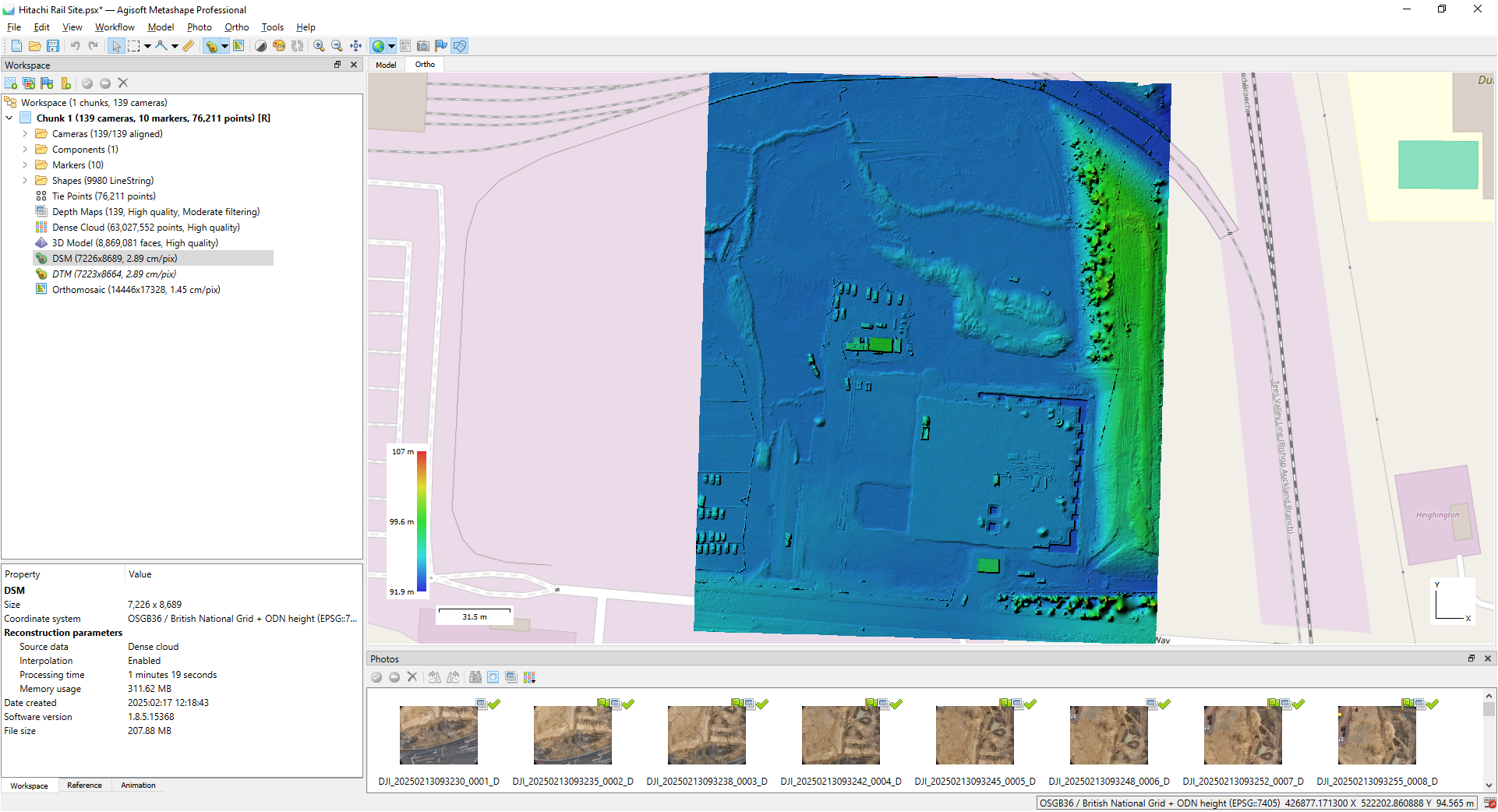
Building a Dense Point Cloud;
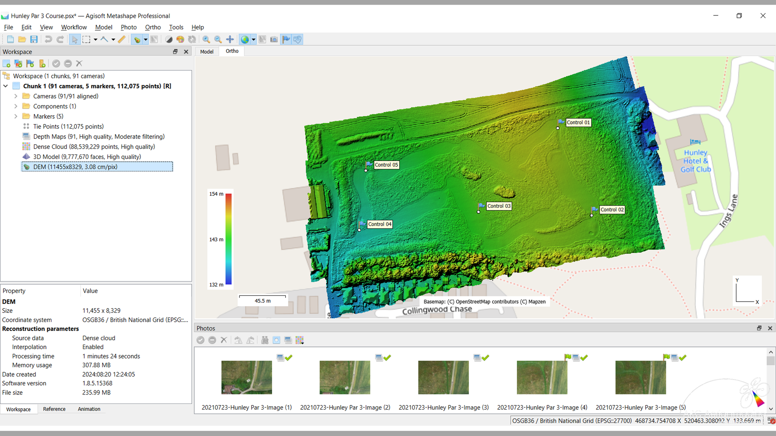
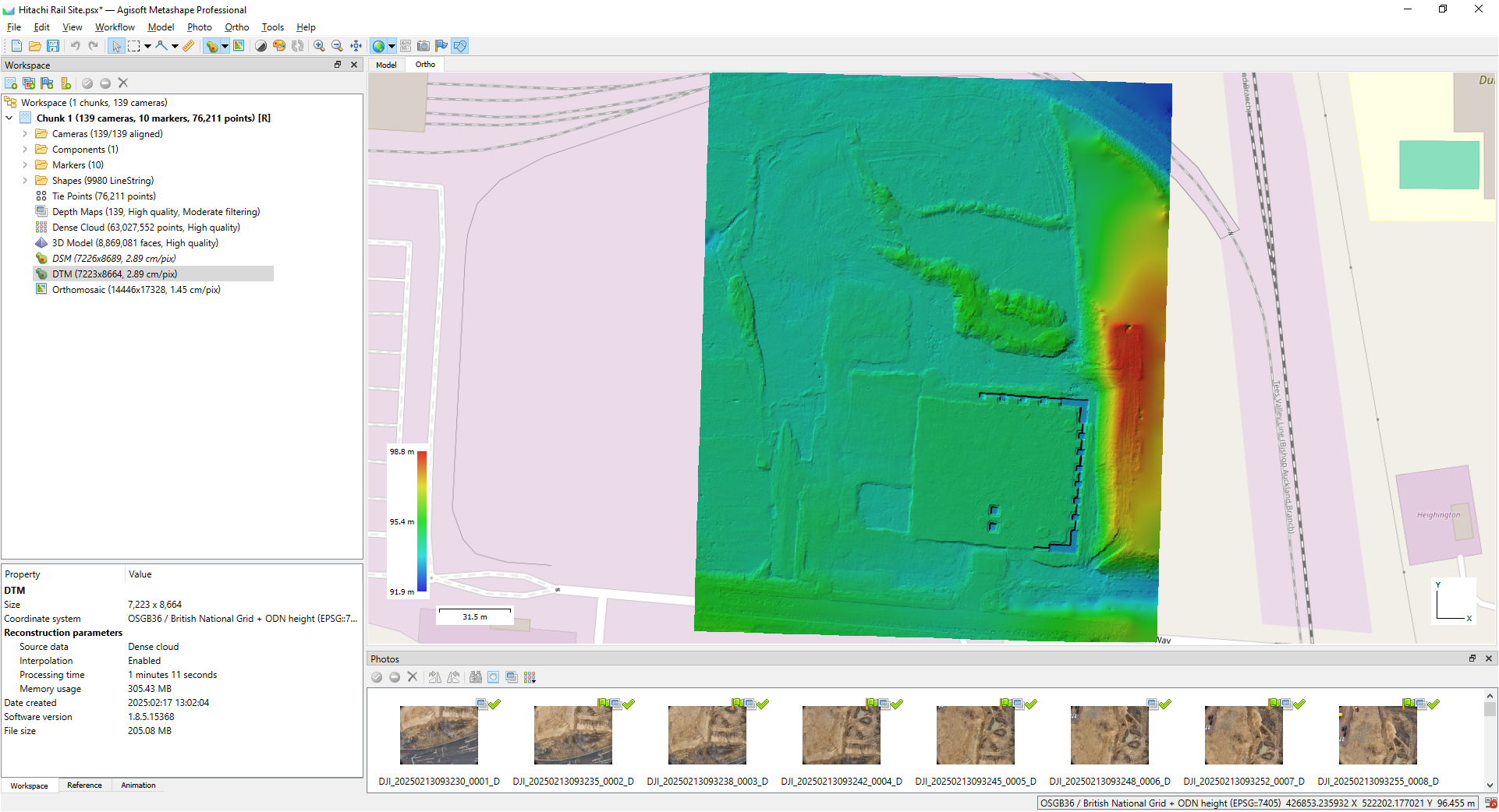
Creating a DEM (Digital Surface Model) from an Unclassified Dense Point Cloud;
Classifying a Dense Point Cloud with specific subject matter attributes;
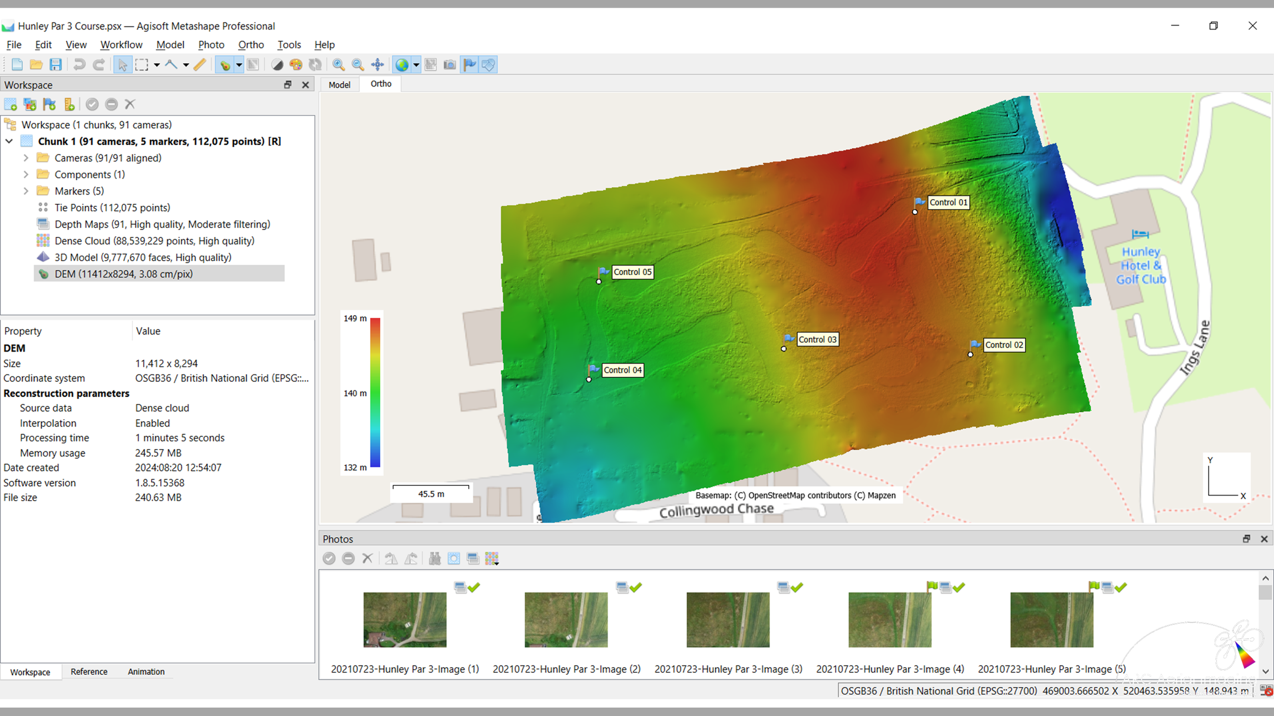
Creating a DEM (Digital Terrain Model) from a Classified Dense Point Cloud;
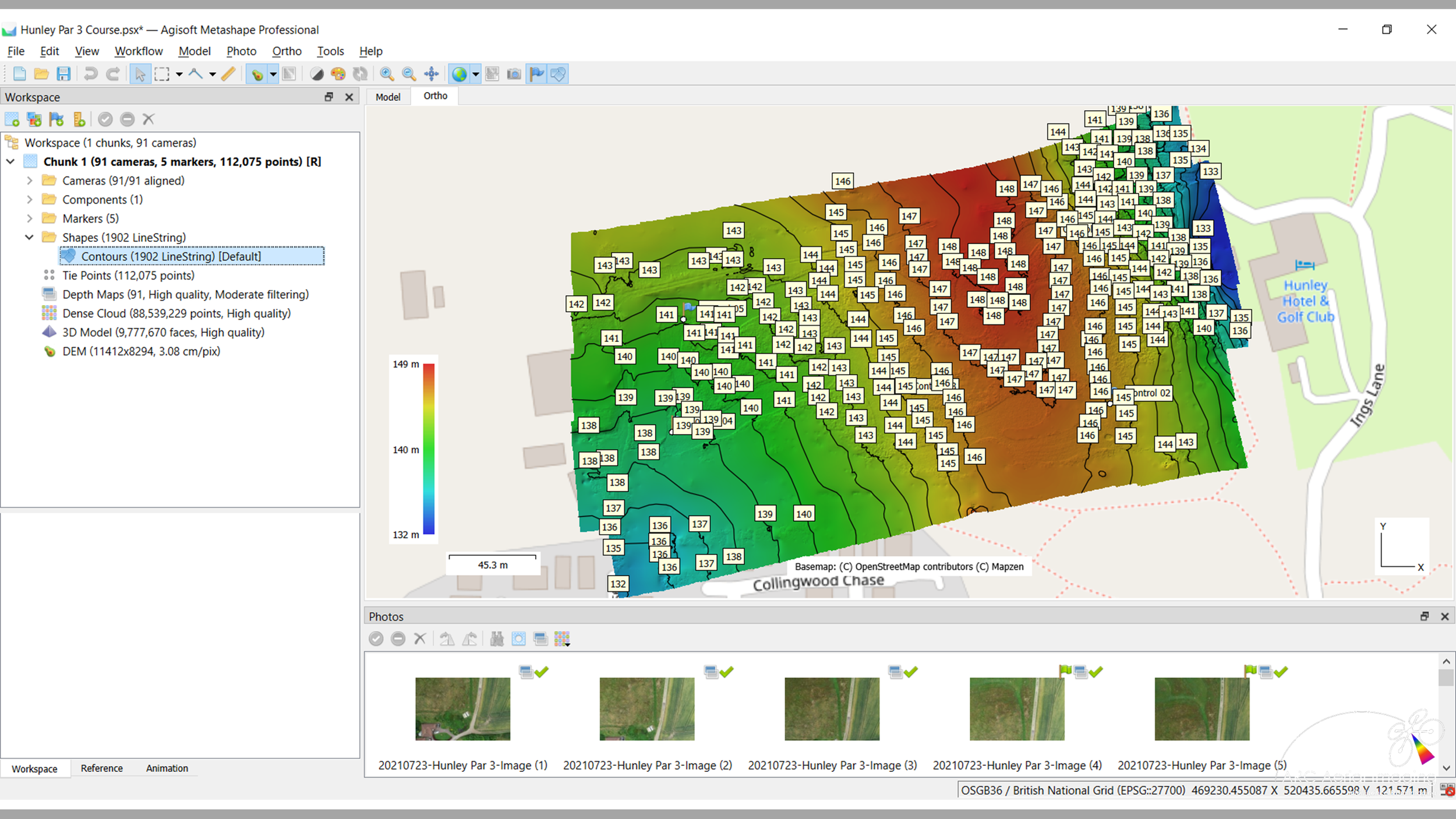
Extracting ground elevation data (contours) from a Digital Terrain Model;
Creating an Orthomosaic;
Building a 3D Mesh and Texture from the Dense Point Cloud for ‘digital twin’ modelling;
Producing a Photogrammetry Processing and Geospatial Accuracy Report;
Saving and exporting various photogrammetry-produced geospatial datasets and in their typical file formats.
It’s instructed in-person by a tutor who has over 30 years of accredited subject matter knowledge including 10 years as a highly-experienced commercial practitioner in photogrammetry with UAVs and their various sensing and is delivered on an optional training needs basis:
Following attendance on our ‘Drone Aerial Imaging Masterclass Course for Mapping, Surveying and Photogrammetry’ at our North Yorkshire-held training venue which is instructed via online/remote learning means
orVia online/remote learning means as a completely standalone training course.
Standalone Training Course
£195.00
The course's LOW TRAINING feeS ARE inclusive of the following:
Agisoft Metashape Pro SfM Photogrammetry software is provided (subject to compatible computing*);
A step-by-step Agisoft Metashape guide as an aide memoir;
A provided sample set of surveying imaging including GCP data.
Course Training Booking Form
Booking is acceptance of our Course Terms and Conditions
It is strongly recommended that attendees on this course would already have a good understanding on how to plan and acquire high-quality UAV aerial imaging - our ‘Drone Aerial Imaging Masterclass Course for Mapping, Surveying and Photogrammetry’ provides that essential training.
* Having robust computing means in place is essential - it’s recommended that it’s Windows OS, a minimum of an I7 (or equivalent) processor, at least 32GB (or more) RAM and a NVIDIA GPU installed.
Mapping Planning with Litchi
Mapping Planning with Litchi Course
Mapping Planning with Litchi
Mapping Planning with Litchi Course
Mapping Planning with Litchi Course.
This additional 1 day and ‘bolt-on’ training course to our industry-leading ‘Drone Aerial Imaging Masterclass for Mapping, Surveying and Photogrammetry Course’ is aimed for those UAV operators that seek further planning controls over their UAV survey flights and aerial imaging acquisitions by advancing from the standard mission planning apps to create semi-autonomous UAV mapping flights.
Primarily applied for automated creative aerial filming with drones, ‘Litchi’ and now ‘Litchi Pilot’ is often overlooked as a credible mapping planning alternative to dedicated mapping planning apps and this short online course neatly bridges the gap between those older and basic flight planning apps (‘DroneDeploy’, ‘Pix4DCapture’…) and the more complex UAV flight mission planning software such as ‘UgCS’ and Ardupilot’s ‘Mission Planner.’
Another benefit is the utilisation of some sub-250g drones towards mapping, surveying and photogrammetry applications with ‘Litchi Pilot’ (see note below) instead of using enterprise-level UAVs where their use within some environments would be inappropriate or if just starting out in mapping and surveying uses with drones.

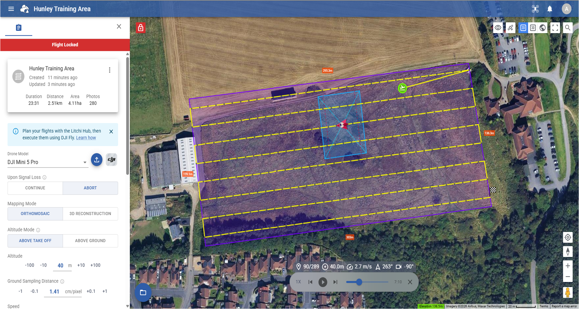


This course is instructed on a one-to-one basis and is delivered in-person via online video conferencing means during one day’s (approximately 8 hours) training duration by an accredited tutor in its subject matter who has decades of planning knowledge and uses with various civil as well as military mission planning and imaging data acquisition applications.
Note - We recommend the use of the DJI RC-N1 (for the DJI Mini 2/3 series, Air 2/2S, Mavic 3), DJI RC-N2 or DJI RC-N3 (for the DJI Air 3/3S, Mini 4 Pro) controllers, a compatible Android tablet/phone and download/installed the open-beta ‘Litchi Pilot’ app for easier transfer of planned flights from Litchi Hub.
Training Topics (Day 1).
Part 1 (AM) - Understanding the Fundamentals of Aerial Imaging.
Aerial Imaging Basics.
Components of an Aerial Sensor - The Detector Array.
Lenses and Focal Lengths.
Understanding Aerial imagery Field of View (FoV).
Spatial Resolution - Ground Sampling Distance (GSD).
How to calculate imagery FoV and GSD with mathematical formulae.
What can affect FoV and GSD on nadir aerial imagery.
Improving aerial imaging GSD.
The basics of Photogrammetry – Aerial Stereoscopy and Parallax.
Photogrammetric principles – what it needs from digital aerial imaging.
UAV Altitudes and Flight Track Speeds.
Imagery overlaps for establishing correct collection leg distancing in Litchi.
Applying the correct camera/sensor settings for imagery capturing.
Part 2 (PM) - UAV flight planning Planning a Mission with Litchi Hub.
Overview of the Litchi Hub desktop planning interface.
Understanding and applying its General and Mission settings.
Step-by-step walkthrough with the instructor to create and saving a mapping mission.
Viewing flight plans in Google Earth for pre-flight assessments.
Exporting/sharing/opening mission flight plans with others.
The Litchi Pilot app - setting sensor capturing settings.
Interval exposures/UAV flight track speeds/imagery overlaps.
Price to remotely attend
£145.00
The course's LOW ONLINE fee is ALSO inclusive of RECEIVING:
Drone Mapping Mission Planning Spreadsheets.
Course Training Booking Form
Booking is acceptance of our Course Terms and Conditions
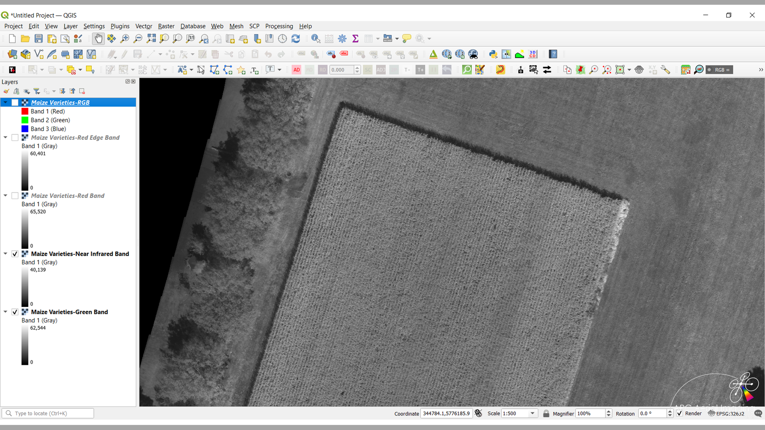
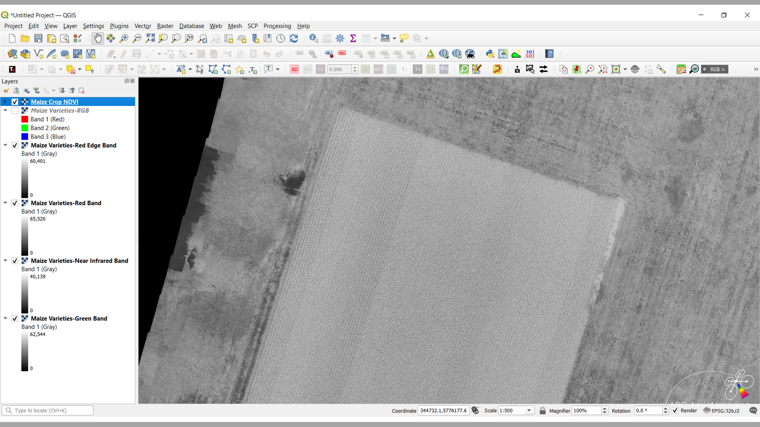
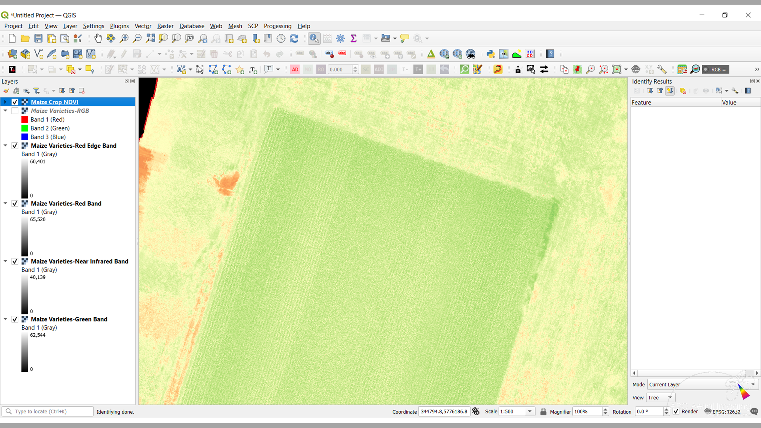
Drone Multispectral Aerial Imaging and Analysis Course for Precision Agriculture
Drone Multispectral Aerial Imaging and Analysis Course for Precision Agriculture
Drone Multispectral Aerial Imaging and Analysis Course for Precision Agriculture
Drone Multispectral Aerial Imaging and Analysis Course for Precision Agriculture
Drone Multispectral Aerial Imaging and Analysis Course for Precision Agriculture.
The agricultural sector is experiencing a significant digital transformation, driven by the demand for improved efficiency, sustainability and smarter resource management. Although advanced agricultural sensors and unmanned aerial systems (UAS) offer enormous potential, simply investing in drone technology does not automatically deliver meaningful results. The real value comes from having the expertise to operate these systems safely, compliantly and accurately while transforming aerial data into actionable agronomic insights.
We provide specialist drone training designed specifically for the agricultural and ecology sectors, equipping you and your team with the practical skills needed to gain a true operational advantage. As the UK’s longest-established aerial sensing training provider, we combine extensive expertise in remote sensing with real-world UAS flight experience.
Our training enables operators to confidently deploy UAS across large areas while capturing the precise, high-resolution multispectral data required for advanced analysis. From rapid field scouting and crop health monitoring to soil variation mapping and wider ecological assessments, we help professionals maximise the potential of drone technology to support informed decision-making and sustainable land management.
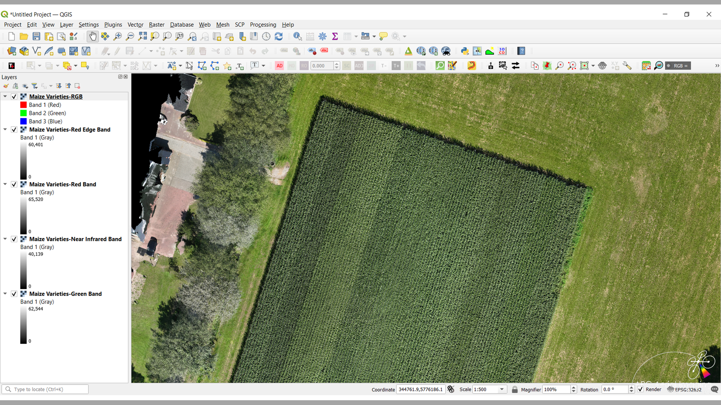


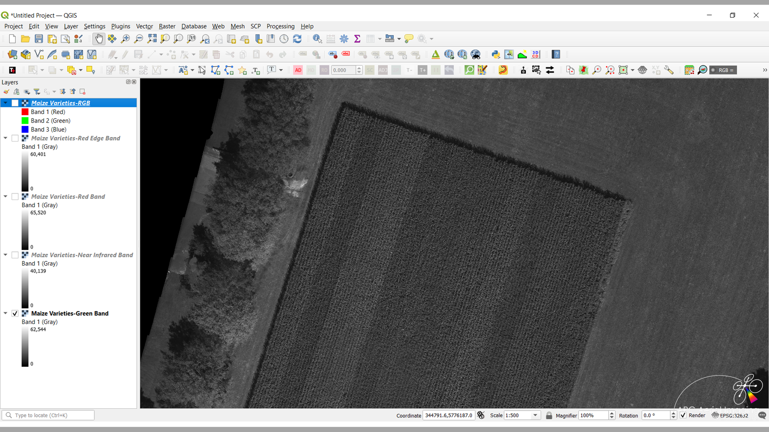


With now accessible UAV-borne multispectral imaging, this 5-day course will cover the fundamentals of those sensing types from elements drawn from its industry-leading ‘Drone Aerial Imaging Masterclass Course for Mapping, Surveying and Photogrammetry’ that would engaged in precision agriculture or other environment-related studies.
From mission planning for the accurate acquisitions and controls of RGB and MS imaging from dual-sensing, the generation of different spectral bands of geospatial datasets from source RGB and MS aerial imaging from SfM photogrammetry (with Agisoft Metashape Pro) to understanding how combinations of different imaging bands can produce various vegetation indices with specific raster calculations using a common Geospatial Information System (GIS) for conducting geospatial and statistical analysis.
Training Days 1 to 3
Our industry-leading Drone Aerial Imaging Masterclass Course for Mapping, Surveying and Photogrammetry
(with added emphasis on multispectral imaging)
Training Day 4
Our Agisoft Metashape Pro SfM Photogrammetry Processing Course
(with RGB and multispectral imaging)
Training Day 5
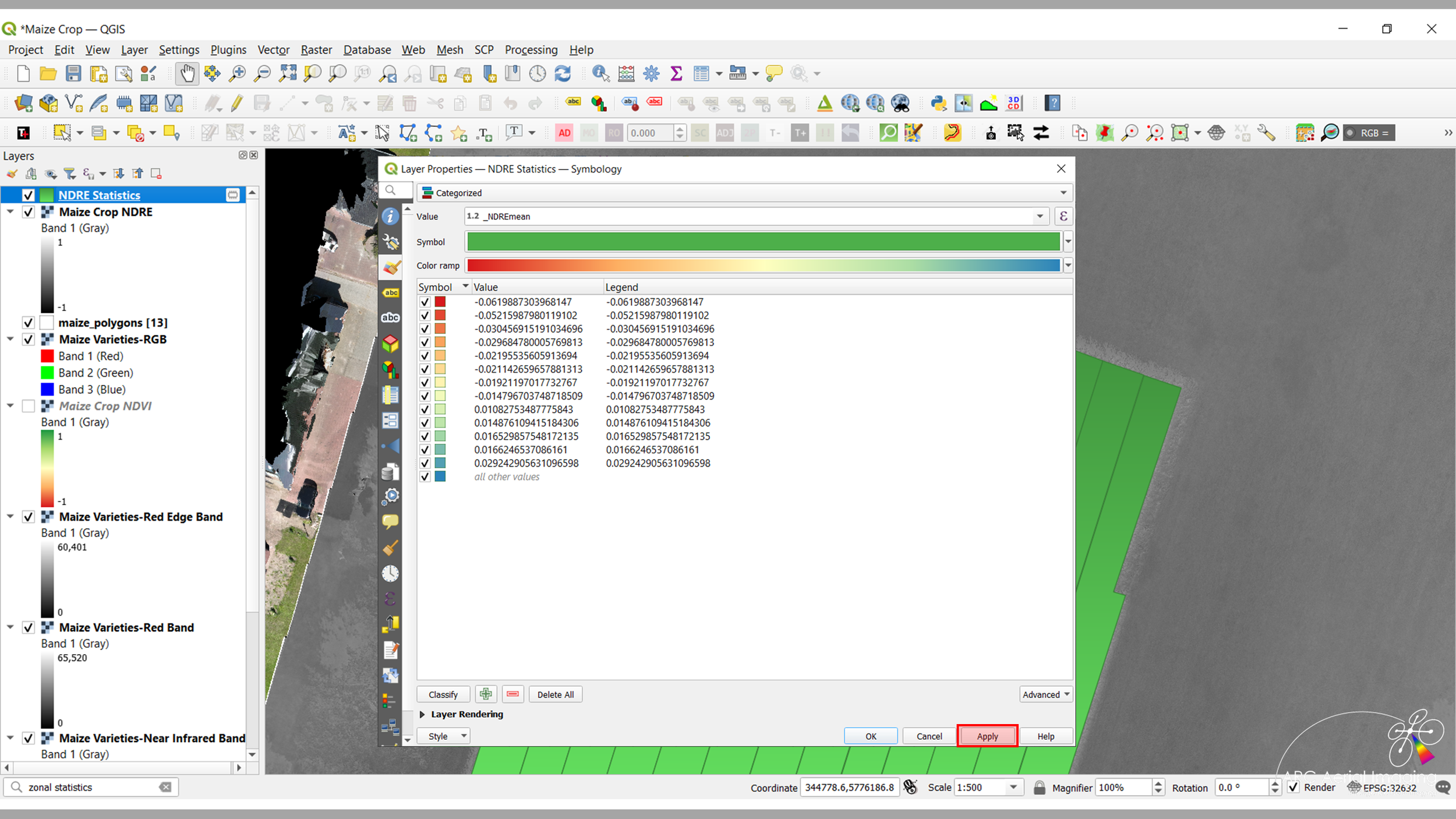
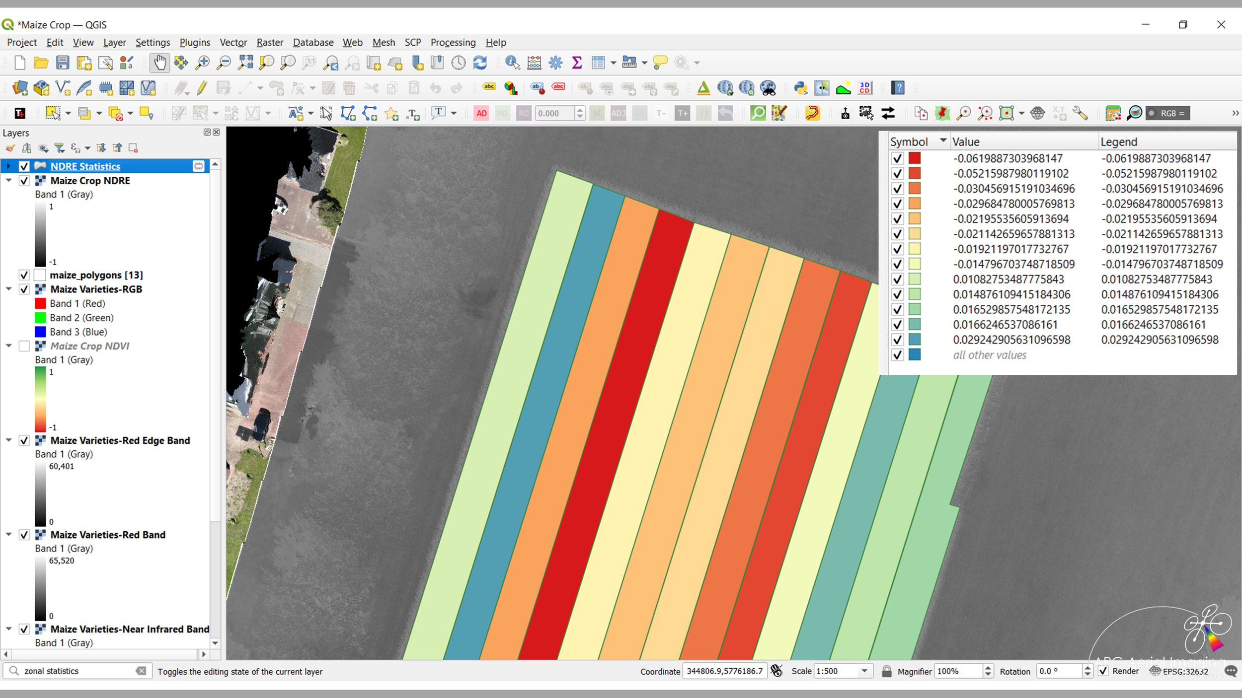
Multispectral Imagery and Statistical Analysis.
Just like our other training courses, it’s instructed in-person by a tutor who has over 30 years of accredited subject matter knowledge including 10 years as a highly-experienced commercial practitioner in photogrammetry with UAVs and their various sensing and is delivered on an optional training needs basis.
Course Applicable Drones
It’s important to utilise the appropriate UAV platform types and dual-sensing towards multispectral-related mapping and surveying. Below are those typical UAVs and sensors that would be compatible to use during the course:
DJI Mavic 3 Enterprise Multispectral
DJI Phantom 4 Multispectral
Course Training Fee
£745.00
Standalone training course via an online classroom
or
Delivered/instructed to in-house UAV teams involved in precision agriculture and other environmental-related studies
Course Training Booking Form
Booking is acceptance of our Course Terms and Conditions